Return to Milestones Vol. 6, No. 1
Surprising as it may seem, there was a Revolutionary fort within the bounds of the terrain now Beaver County that has never been identified or mentioned by any of the writers of local history in the area. Neither Bausman's nor Warner's histories, nor Dallas Albert's Frontier Forts in Western Pennsylvania, nor even the Hon. Daniel Agnew's writings' have taken notice of it.
That the fortified post existed and rated well in importance is amply documented in the military correspondence of the time, even with Continental Congress and the Board of War.(2) During 1777-1778 and part of 1779, troops from Fort Pitt were stationed there. A probable reason for this neglect may have been found in the difficulty of establishing a definite location of the post, evidently a stockaded log blockhouse having accommodations for more men than the usual frontier cabin.
Fort Pitt had initially been held by Virginia militia, but, in April, 1777, Continental Congress resolved that Brigadier General Edward Hand, of the Continental Army, should proceed to Fort Pitt to command the Continental troops there (3) (mainly part of the 13th Virginia Regiment) and to raise militia from the western counties of Pennsylvania and Virginia. He arrived there on June 1, and commenced organization of defense of the frontier (4) then in a state of alarm from widespread Indian attacks.
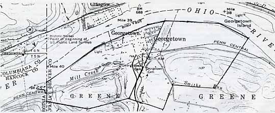
Within three days, he found upon his desk a report of the fortified posts upon the Ohio River (including those upon the Allegheny, then considered an extension of the Ohio). The names of most of the forts are familiar to the reading public and students of the history of this tristate area -- Fort Armstrong, Holiday's Cove, Fort Henry, and Fort Randolph. The unfamiliar one on the list was that "at a place Call' Rordons bottom about 40 miles below this post [Fort Pitt] an Officer and 15 men." This memorandum was dated at Fort Pitt, June 3, 1777.5 The latest (1978 United States Geological Survey Topographical Map, East Liverpool North (Ohio) quadrangle, pinpoints 40 miles in the Ohio River channel precisely at the Penn-Ohio state line.
On July 25, 1778, Major Jasper Ewing, General Hand's brigade major and brother-in-law, recording the boats, etc., at the posts on the Ohio River, spotted one canoe "At Reardon's Bottom." The relative importance of this defensive post is indicated in the letter from Major Henry Taylor dated at "Reredons Bottom 17th August 1777," as follows: "...As the Chief of the old posts was below Logs Town, I marched the men down to this post, and went down myself to the Lower Posts ... I then ordered the Officers to meet at this post (Reardon's Bottom) to agree on the place (for a meeting of officers from all of the posts, from Kittanning on the Allegheny to Point Pleasant on the Ohio).(7) Major Taylor, at that time considered it "the Chief of the old posts."
By November 3, 1778, the new commander of the Western Military Department, General Lachlan McIntosh, had construction of Fort McIntosh, at present Beaver, well advanced and found it necessary to build another, Fort Laurens, upon the Tuscarawas, about seventy miles advanced. During his absence, conducting part of his army on this business, he left Colonel Richard Campbell in command of Fort McIntosh and dependent posts with explicit instructions for completing the fort structures and forwarding supplies to Fort Laurens. McIntosh's orders particularized thus: "You are Immediately to take charge and Command of the Post (Fort McIntosh) ... to receive reports every day from the Stations upon the Onio River, Viz. Raroon's Bottom, Holiday's Cove, and Fort Henry...(8) Again, early in 1779, General McIntosh, reporting to the Board of War, wrote from Fort Pitt, on January 11: "On account of scarcity of our provisions I have kept ... small parties of the 13th [Virginia] Regiment at Rairdon's Bottom, Holliday's Cove and Ft. Henry at Wheeling, all upon the South side of the Ohio below Beaver ... and not a single militia man under pay in either of them. " (9)
All of the foregoing evidence demonstrates that there was a frontier armed post upon the south bank of the Ohio River, within the limits of present day Beaver County, Pennsylvania, called "Reardon's Bottom" (spelled variously, according to the whim of the writer). The record testifies to the importance of the station to the line of defense during more than two years of the Revolutionary struggle.
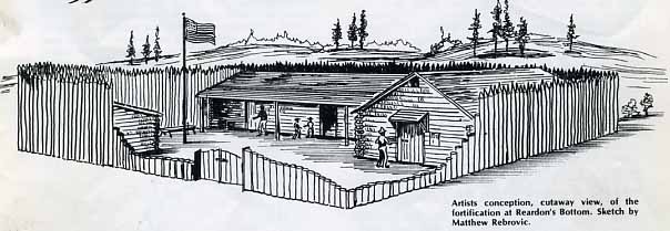
We can only conjecture as to the size and form of the fort at Reardon's Bottom, but it must have been larger than the loopholed log cabins, or blockhouses, often termed forts. We know that at one time it sheltered fifteen soldiers and an officer, in addition to the Reardon family. In that case, one or two outhouses would have been required to house the additional men, and all would have had to be surrounded - at least joined - by a stockade.
With its disappearance from the official records, all trace of the fort vanished. No positive identification of the exact spot it occupied is possible, due to confusion in the land records and almost fantastic speculations in real estate even beyond that common to the times. The Reardon family sold out and entirely disappeared. Reardon's Run entering Raccoon Creek, in Independence Township, seems to be the only visible trace of the name that remains.
The land records have been fruitful to a certain extent, but have proved less positively productive than intriguing. The land records of Beaver County can offer very limited help, since only records since 1800, the year in which Beaver County was organized, are available. Prior to that time, the land within the great bend of the Ohio River fell within Washington County, after its formation in 1781. Prior to 1785, the same land was being warranted and surveyed by both Virginia and Pennsylvania, because not until 1785-1786 was the western boundary line of Pennsylvania surveyed, dividing that state from Virginia and from the Northwest Territory. The early records of Washington County are incomplete and quite inaccessible, being stored elsewhere than in the courthouse. The Bureau of Land Records of the Pennsylvania Department of Community Affairs has been most helpful, for which thanks is extended to the Bureau's Director, Mr. E. D. Price and Mrs. Helen Jones of the staff. It should be added that the two states agreed, in 1784, that Pennsylvania should recognize and accept Virginia certificates for land claimed and to adjust any conflicts of claims between the two parties.
With this background fill in, the business
of locating the fort site can be examined. It is apparent that
a man named John Reardon (Rairdon, Rorden, etc.) settled upon
some bottom land along the Ohio River and established a claim
to the land by a method known as settlement and improvement, the
exact site location today uncertain. General Andrew Porter, in
his journal of the survey of the state boundary line, mentioned
above, recorded on June 17, 1785: "Incamped near the banks
of the Ohio, at the mouth of Mill Creek. This place is called
Raritons Bottoms." (10)
The present Penn-Ohio state line strikes and crosses the Ohio
River precisely at the mouth of Mill creek, by the Geological
Survey Topographical map, above referred to. The surveyed tract,
however, extends 438 perches (rods) by three courses measured
eastward from the state line upon the river bank, including the
elevated plain later occupied by Georgetown. Significantly, the
name applied to the tract, upon the survey plat, suggests the
sequel: "The Bone of Contention, 376 acres 138 [square] perches.
" Two hundred six acres of this tract had originally been
surveyed upon a warrant issued to Colonel Robert McPherson, then
serving in the state Assembly from York County, a former officer
in General Forbes' campaign, 1758, and commander of a regiment
in Washington's Flying Camp in New Jersey, in the Revolution.
Date of the warrant for survey was February 18, 1785. A certificate
for the same land, however, had been granted by the state of Virginia
to James Henderson, of Greenbriar County, Virginia; and, upon
orders of the Pennsylvania Board of Property, in Philadelphia
dated September 15, 1784 and March 7, 1785, with instructions
for a survey to be executed. Deputy Surveyor Generals Pressley
Nevill and Matthew Ritchie performed the duty on February 11,
1786. In the meantime, Henderson conveyed his title, having sold
the land, to Robert D. Dawson, by deed dated January 30, 1786.
Hence, Dawson's name appears as the grantee upon the survey return
received by the surveyor general's office on May 3, 1786. A warrant
of acceptance was issued on March 23, 1790, and the patent was
issued to Robert R. (D. is meant), Dawson on March 30, 1790. (11)
The lowest point in Beaver County is marked at the state line and the mouth of Mill Creek upon the official map of the county. The high plateau upon which the town of Georgetown was later built occupies the extreme northeasterly angle of "The Bone of Contention" tract. The town plat was laid out by Robert D. Dawson and his father, Benoni Dawson in 1793 (12) One last reference to "The Bone of Contention" is furnished by an indenture made on December 31, 1804, conveyed to Benoni Dawson, Sr., his title to the tract of 376 acres 138 perches by deed dated November 15, 1794. (It also appeared by this indenture that Robert Dawson had two partners in the land deal.) This record is preserved in Deed Book A-pp. 402-404 in the Beaver County courthouse. (13)
No conclusive evidence has yet been adduced to fix upon the location of the Reardon's Bottom fort. It seems that General Porter may have passed along a piece of local lore to the effect that the name "Rariton's Bottoms", as he expressed it, may have locally been applied to all of the low lying lands along the river bend. This is suggested by the fact that the tract contiguous to the former tract, lying east and northeast of it, was named "Reardon's Bottom" on the survey plat return, also in the final patent. Porter also wrote that on his return from a visit to Fort McIntosh, he "lodged at Mr. Dorson's" (14) The triangular plain, lying along the river, apparently gave the descriptive name to the entire 378 acre tract.
The patent (15) regarding this tract recites the following: "Which said Tract was surveyed in Pursuance of a Warrant dated 18 February, 1785, granted to the said Joseph Giffillen whose right became vested in the said John Lee Webster and Amos Loney and Francis Holland ... [who] by Indenture dated 21 January 1792 released all their right in the tract [int al] to the said John Lee Webster, " to whom a patent was granted February 25, 1795.
The course of events, however had not run as simply as this abstract may appear. At the end of the survey return (16) is this note: "The same Survey is ret'd for Jn Rearden assignee of Zachanah Davis on a warrant granted to said Davis for 400 acres dated y 15 July 1785. " This was the cause of an appeal to the Board of Property, meeting in Philadelphia on July 7, 1787, presided over by Benjamin Franklin, president of the board by virtue of his office as president of the Supreme Executive Council of the state.(17) it seems that John Reardon allegedly granted a power of attorney to his son Daniel Reardon, who sold the land beforementioned to one James Crawford for 3,000 pounds Continental money, who by deed dated March 10, 1784, conveyed the property to Joseph Gilfillen, who appears upon the survey return. The latter conveyed it to Loney, Holland and Webster, but, as stated above, the other two had released their interest to Webster. In the meantime John Reardon sold the tract to Zachariah Davis, who had a survey run for himself, as noted upon the return in the surveyor general's office. The elder Reardon denied that he had given his son a power of attorney to sell the land, but it was amply supported by affidavits that he had granted the power of attorney and that John Reardon had received the 3,000 pounds from Crawford. The Board, Franklin presiding, ordered the survey to be entered at the surveyor general's office and a patent issued to Gilfillen.
It only remains to dispose of the theory held by some persons, that the site of Reardon's Bottom fort may have been at Georgetown, since there has been testimony that a "blockhouse" existed there, incorporated within a larger, presently standing house. Locally it has been called "the Old Blockhouse". A good account of this relic of pioneer days, with modernized functional treatment, is set forth in a work of that indefatigable and meticulous Ohio historian, Thomas J. Malone. (18)
The date of its construction by Benoni Dawson, however, must have been earlier than the date he assigns as 1796, two years after Wayne's victory over the Indians at Fallen Timbers, which eliminated the threat of Indian incursions. In 1792 occurred the ambush murder of James Clark, pioneer of Smith's Ferry settlement, when "his wife ... took a canoe and carried their child across the river to the blockhouse at Georgetown. " ` It is not- claimed by historians that Dawson's blockhouse was the "Reardon's Bottom" fort, but local tradition has a tendency to imagine many events as earlier than they actually occurred.
It is the writer's considered opinion that the mouth of Mill Creek being the lowest ground in the whole large area and thus subject to spring flooding, the Reardons chose the fine bottom land upstream from the high Georgetown location. It is worthy of remark that no reference to the mouth of Mill Creek appears in the army dispatches, only mentions of Reardon's Bottom. The landing for boats implied in the memorandum to Hand, of July 25, 1778, would have been possible since the shallow water was near the south shore of the river, the channel being close to Grape Island nearly opposite, according to Cramer's The Navigator (2O) of 1814. The mouth of Smith's Run may have offered an ideal landing place wholly within Reardon's tract.
Although not a part of the declared purpose of this investigation to prove neglect of an important historical site, it is nonetheless desireable to understand and to observe one of the dominating phenomena in our American Revolutionary society. It is not too much to say that lust for land was hardly secondary to patriotism among a great majority of gentlemen of spirit, in and out of the patriot army. The impetus to land speculation was an obsession that possessed nearly every individual who had a few dollars in his pocket, in every walk of life including members of the Continental Congress. Ownership of landed property was the best possible recommendation in endorsement of a young suitor for a fair lady's affections. There existed in America no securities exchange, and the unique commodity with the most potential for rising value was land. The real estate transactions just cited exemplify the trend of the times.
1 . Joseph H. Bausman, History of Beaver County, Pennsylvania (New York, 1904): J. F. Richard and T. Henry, comps., History of Beaver County, Pennsylvania (Philadelphia and Chicago, 1888; George D. Albert, Second Vol. of Frontier Forts of Pennsylvania (Harrisburg, 1896); Hon. Daniel Agnew, A History of Pennsylvania North of the Ohio and West of the Allegheny Rivers (Philadelphia, 1897)
2. L. P. Kellogg, Frontier Advance on the Upper Ohio (Madison, Wis., 1916), 198; Worthington C. Ford, Journals of Continental Congress (Washington, D.C., 1904-1931), 13:115.
3. Ibid., 7: 247, 252
4. R. G. Thwaites and L. P. Kellogg, Frontier Defense on the Upper Ohio (Madison, 1912), 1 n; H. R. McIlwain, Journals of the Council of the State of Virginia, 2 vols. (Richmond, 1931), 1: 348, 358,
5. Thwaites and Kellogg Frontier Defense, 4.
6. L. P. Kellogg, Frontier Advance, 122.
7. Thwaites and Kellogg, Frontier Defense, 44.
8. Kellogg, Frontier Advance, 164.
9. Ibid., 198; Ford, Journals of Continental Congress, 13:115
10. Milestones, Vol. 5, No. 3 (1979), 27.
11. The original Warrant to Accept, the original Survey plat map and description, also the Patent Certificate are preserved in the Bureau of Land Records, Department of Community Affairs, Harrisburg, Pa. (Warrant, 136-D; Washington County; Survey, Y-163; Patent P-15-269.) Certified photocopies of these documents, with their endorsements, are in possession of the author.
12. Warner, History of Beaver County, 561.
13, Deed Book A, pp. 402-4, Office Register of Deeds, Beaver, Pa.; also reprinted in Thomas J. Malone, John Bever, Pioneer Surveyor, 27-28.
14. Milestones, Vol. 5, No. 3 ~1979), 28.
15. Patent Book P, Vol. 22, p. 484, Bureau of Land Records.
16, Survey Book C, Vol. 54, p. 216, Bureau of Land Records.
17. Pennsylvania Archives, 3rd series, 1:540-1,
"Minutes of the
Board of Property, 1765-1791."
18. Malone, John Bever, 30-1.
19. Warner's History of Beaver County, 585.
20. Zadok Cramer, The Navigator (Pittsburgh, 1814), 75, 78-9.