Click Here to Return to Milestones
A glimpse at one of the smaller, lesser-known county waterways, its tributaries, their origins and some names of the people who have lived in the locality.
Every year, when the spring thaw begins, the rivers and major creeks of Beaver County absorb the melting snow and rain and swell beyond their normal size. Too often we fail to consider that our lesser waterways, although smaller in stature, are similarly affected and merit some concern. They may not play as important a part in the scheme of things, like providing a link in transportation, but they are invaluable in other ways. One of their most important contributions, although only more recently being understood, is in the ecological cycle in the development and nurturing of wetlands.
Judge Daniel Agnew, in his widely published Court House speech in 1877, detailed an index of our major waterways in a most lucid manner and we quote him here.
"Entering the county on the southeast at the mouth of the Big Sewickley, the Ohio ran northwest to the mouth of the Big Beaver, then turning in front of the town it ran a little south of west to the Ohio State line. The Big Beaver coming in from the north, and bearing onward the waters of the Mahoning, Shenango, Neshannock, Slipperyrock, Connoquennessing, Brush Creek, Hickory Creek, Brady's Run, and minor streams, concentrated the valleys of all these water courses, like the radii of a circle, on the Ohio at the mouth of Big Beaver. So Raccoon entering the county at White's Mill on the south ran north nearly midway, entering the Ohio just below the Beaver plain. Thus nature had planted this fine plateau right at the center of four great valleys, on the north, east, south and west. These valleys and their corresponding ridges constitute the great channels of travel, all centering here. These again are fed by the smaller valleys and ridges leading into them - the Six Mile Run, Four Mile Run, Two Mile Run, Dutchman's Run, Crow's Run, Tevebaugh, entering the Ohio on the north side, and Logstown Run; and various streams down to Mill Creek on the south side; while Raccoon bore to its mouth the waters of the Big and Little Travis, the Service, and other streams. Thus stood Beaver at this natural center of travel, and the men of 1800 chose the only true center of convenience, population, and territory. It was no leap in the dark, but the unbiased judgment of men consulting the public interest. They knew that the natural course of travel is along the valleys, and upon the ridges, such as the Ohioville, Achortown, Broadhead and Frankfort roads, and that public thoroughfares do not seek to cross hills and dales, in ups and-downs, like the teeth of a saw, at the expense of horse flesh, vehicles and taxes. These reasons, self-evident then, have never changed, because nature remains the same, and even railroads follow the same law of travel."
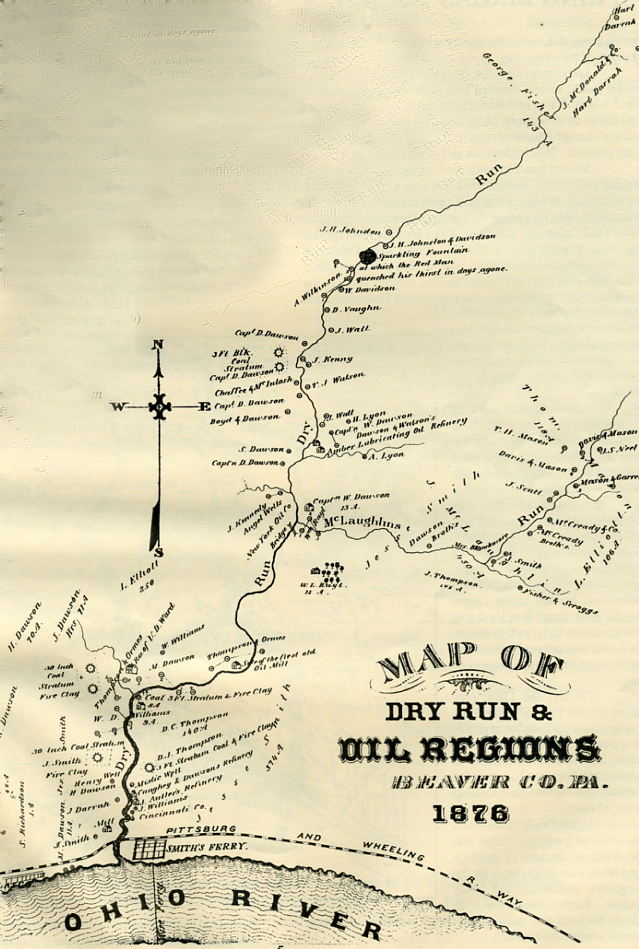
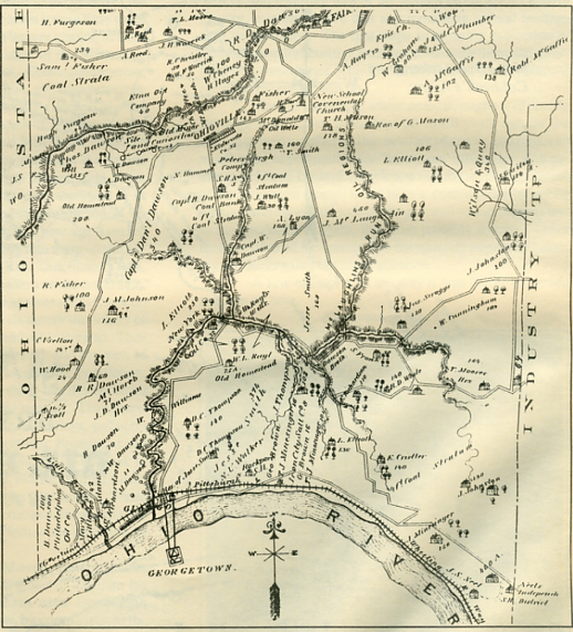
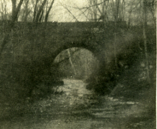
Were the judge to have named every existing source of water in the County, he would have had to lengthen his speech considerably. As, alas, he did not name Dry Run in Ohioville Borough. Its volume of flow, by comparison to the others named, is generally small. But it does drain about onefourth of the Borough's 25 square miles (see map), which contain dozens and dozens of springs that seep into acres of swamp land. These in turn join together, like a giant web or a Japanese fan, and eventually drain into either Upper Dry Run or McLaughlin's Run, which then join and form Dry Run at the old stone bridge (see picture). Dry Run then flows for over a mile to Smith's Ferry where it exits the Borough into the Ohio River.
As stated above, the usefulness of large waterways is common knowledge. And the need of pure water sources for the survival of man and animals cannot be questioned. But wetlands have generally been looked upon as a nuisance. Space wasted, something (if possible) to be eliminated - drained, ditched, sewered and/or covered over. Only in recent years has the value of wetlands been appreciated.
In a letter from the Beaver County Planning Commission, dated February 21, 1992, in regards to the Beaver County Natural Heritage inventory...
A natural heritage site is an important biotic (living) resource such as an exemplary natural area (e.g., an old-growth forest community), habitat for endangered, threatened or rare plants or animals, or areas that are important for open space, wildlife habitat, and recreation. With the rapid rate of development and resulting loss of the natural landscape in Beaver County, it is imperative that any remaining natural heritage sites be protected. The first steps in ensuring protection of environmentally sensitive areas are to identify them and determine their importance. This is what the Beaver County Natural Heritage Inventory will do.
Many of the people who roamed throughout Ohioville Borough (then Ohio Township) 50 to 60 years ago, in the section woven together by this network of creeks and runs, can recall great opportunities for "hands-on" adventure with nature at its finest. Little did they know that the pristine condition of the area (even though it had been accosted twice before by man - farming and oil well drilling - and bounced back) was to be deteriorating again, this time possibly forever. Other rural sections of the county that are sparsely populated possibly are undergoing the same situation.
A few examples of the way it was before are made mention of here.
In the spring, when the sun began to warm the bottoms of the small valleys, green shoots began to make their magical appearance. One such spot had a proliferation of violets. First came a few dozen. Then hundreds. Then what seemed like millions. It was an area that made an ideal and delightful playground for young children. The name coined to identify this place automatically became "violet patch" and remained so for many years. There was a spring nestled into the hillside to the left of the "violet patch."
A large flat rock, supported on either end by rocks sunk deep into the earth, sheltered a pool about 18 inches deep. If you knelt beside the pool and scooped quickly, you got a drink of cold, pure, delicious water. The braver one sjust bent over and drank directly from the pool, but it contained a resident frog, and doing this you might come face to face - or eyeball to eyeball with him. Mostly, on approaching, you just heard a "plop" and he disappeared into the spring. But there was room for everyone - and everything. Today there are few, if any unattended springs that you dare to drink from in the county.
The trickle from the spring bisected the violet patch and ran to the right, draining into a narrow, mucky swamp several hundred yards long. It was always covered with emerald green grass, and, where the water cut a groove, you could see patches of pale blue clay.
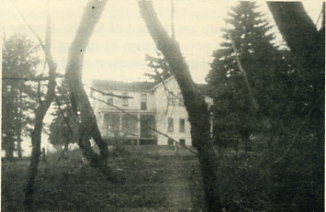
Looking up the slope, due west from the center of the violet patch, several hundred feet, stood a large, old, frame farm house. It was surrounded by enormous pine trees which gave it an air of mystery. And, like a bastion or a fortress, an aura of strength emanated from it. It was the Elliott homestead (see picture). The children felt safe as they played there.
Several hundred yards down the creek this particular branch joined with another creek that was formed from three other springs. It was a bit larger. Up that hollow was the old swimming hole, carved out by a group of the older boys who, with a little ingenuity and effort, found a way to keep cool on those hot summer days. (Pool City wasn't around then.) A colony of muskrats moved in and played havoc with the earthen dam with their constant tunneling. But revenge came in the winter, when traplines run in that area provided many pelts that fur companies were eager to buy. Other fur bearing animals were also harvested along these various runs - oppossum, skunk, raccoons, weasels and an occasional fox or mink.
Across the road from the entrance to the Midland Sportsmen's Club on another tributary of McLaughlin's Run, was another large swampy area. For those favoring the French cuisine, a dozen or so pairs of frog legs could easily be obtained here by a diligent hunter in a short while. And an occasional turtle could be seen lurking in the rushes if one was inclined toward turtle soup. Minnows, horned chubs (some caught were larger than legal size trout), shiners and crawfish were to be found in every pool of water of any consequence in this network of runs.
(Today, the 1,000 plus acres of the Pennsylvania State Game Lands still retains its primitive posture but, outside its perimeters, land that is not guarded is abused and becomes fair game for persons looking for a place to dump their rubbish.)
Upper Dry Run contained its share of swamps. Some that bordered on thickets of saplings and brush were ideal places for the ungainly woodcock and noisy grouse. Further toward the open fields flocks of tiny quail would flutter and sing their occasional soulful 'Bob white'.
Were the statement put forth that the lower Dry Run area was once like a microcosm of the Skyline Drive and the Grand Canyon combined, there would undoubtedly be scoffers galore. But once the top ridge did have huckleberries and dewberries growing between the clump of mountain laurel, strawberries and blackberries in season, and deep in the canyon were bushes of the rare and beautiful buttonberries. Below, the deep canyon - exact depth varying - still exists, where you must look straight up to see the sky. And there are still places that sunlight never penetrates. And the hillside of shale still crumbles when you pull a lump of soft coal out of the two foot high seam. The largest free standing rock seen in the county to date still exists there.
But whether the canyon is 500 or 1,000 feet deep, it is not deep enough or remote enough to escape modem man. The hundreds of tires and twisted rusty major appliances that are lying there serve as mute evidence to this. One wonders what the Indians or early explorers who first viewed the beauty of Dry Run.