
Return to Milestones Vol. 5, No. 3
The polygonal section of country that is now Beaver County, Pennsylvania, has always occupied a uniquely strategic position in relation to the great western movement of civilization and settlement.
Lying astride one of the great rivers of the continent (the Ohio), also controlling the tactically sensitive stretch of the Great Trail, this segment of the domain of present Beaver County dominated the most important corridor of travel and communications north of Cumberland Gap.
All of the significant early military expeditions to the west passed by this corridor to the Muskingum or the Scioto. Relevant to this review, mention should be made of the following: Colonel Bouquet's march to the Muskingum (1764); Lord Dunmore's expedition to the Scioto (1774); his army of 750 men passing down the Ohio River in nearly as many canoes and bateaux for provisions.1 General McIntosh's expeditions to build Fort Laurens (1778-1779), and to reinforce the same.
There were contingents with supplies that went down the River to reinforce General Harmar's expedition (1790) and General St. Clair's disastrous expedition (1791), as well as General Wayne's successful campaign by river, from Legionville to Fort Washington, at Cincinnati (1794). Logistical support went to all of these military campaigns, either by water or by land, and in the intervals between the warring episodes, countless trading ventures were carried on, mostly by packhorse trains, over the Great Trail. This busy road, already deeply worn by the marching armies, became the Tuscarawas Road and Lisbon Road of today. It should be observed that, at the fording of the Big Beaver, the river and land trail routes diverged.
It is interesting to note that the area now Beaver County has undergone the jurisdiction of more parent county governments than any other that can be mentioned. Originally, all of the land west of Bucks (Buckinghamshire) and Chester Counties belonged to Lancaster. In 1749, the county of York was formed west of the Susquehanna River (then including Adams); *and in 1750, the County of Cumberland was organized, comprising all of the vast territory to the end of Penn's grant, five degrees from the Delaware River. The latter county was divided, in 1771, at the top of Ray's Hill mountain to form Bedford County with jurisdiction to the limit of the province. Then, in 1773, that county was divided at the crest of Laurel Ridge to form, Westmoreland, the last county organized under the- colonial government of Pennsylvania, still under the crown of Great Britain.
From the beginning of 1774 and during the long war of the Revolution, the areas of Westmoreland now Fayette, Greene, Washington Counties and much of Allegheny, even Pittsburgh, were largely settled by, and claimed by, Virginians. Particularly bold were the settlements on Cross Creek (in present Cross Creek Township, Washington County), in 1770-1771. Other adventurous pioneers were the families of George Baker and Levi Dungan who thrust forward into the wilderness in the great bend of the Ohio, in the present townships of Center and Hanover, Beaver County, as early as 1772.2 Much dissension occurred and pressure was exerted to throw the whole region into the Virginia government, but that state ceded its northwestern lands to the Federal Congress, in 1781-1783, and agreed to a survey of a temporary line, which was accomplished in the latter year.3 Establishment of Washington County, in 1781, was a necessity for proper government of the territory. The Virginia landowners vehemently objected that they had been abandoned by their state, whereupon, Pennsylvania resolved to honor their patent rights, and very many land titles within the mentioned counties, including Beaver are recorded as "accepted upon a Virginia certificate."4 Washington County at that time embraced all the land west of the Monongahela and southwest of the Ohio to the western boundary of the state, still undefined. It included present Greene County and all of the "southside" townships of Beaver. The parts of present-day Beaver County north and east of the Ohio River still belonged to Westmoreland until, on September 24, 1788, Allegheny County came into being and was given the area stretching from Pittsburgh north to Lake Erie.5
After nearly four decades of wrangling in both England and America, during which time the assembly of the colony often refused to acknowledge jurisdiction or to defend the land west of the mountains,,6 Pennsylvania and Virginia finally agreed to define and demarcate the western limits of the state (1779). Instead of attempting to duplicate the wavering line five degrees distant from and in confirmity with the course of the Delaware River (as a literal interpretation of Penn's Charter would have required, but which would have excluded much of present Beaver County the commissioners of the two states finally agreed to establish upon an extension of the Mason and Dixon line a point, five degrees of longitude from the Delaware at the same Latitude, and, with that point as its southern terminus, to survey a meridian due north to the south shore of Lake Erie.
This map compares the various solutions proposed to resolve the Pennsyvlania-Virginia boundary controversy. All are based on various interpretations of William Penn's grant from Charles 11 in 1681 and the 1609 charter granted to the' London Company [South Virginia] by James 1. The vertical dashed line was suggested by Goveinor Dunmore of Virginia and supported by Washington. The curved, dotted line was proposed by John Penn and preferred by Franklin. The Virginia Legislature wanted an additional chunk of land up to the 40th parallel.
Controversy, sometimes violent, succeeded, so that it was in the winter of 1782-1783 that Alexander McClean and Joseph Nevill ran the temporary line, which was productive of more litigation. In 1784, a distinguished group of scientists proficient in both astronomical and practical surveying sciences accomplished the extension of the Mason and Dixon line by setting up observatories near each end of the line and making astronomical observations and almost limitless calculations, based upon the axiomatic premise that 5 degrees of longitude equal 20 minutes of time, as measured by finely synchronized timepieces. Teams of commissioners of both states worked for six weeks at stations at each end of the line, near the Delaware and in the wilderness of southwestern Pennsylvania. This was one of the first great achievements of terrestrial surveying in America, in fact in the world.8
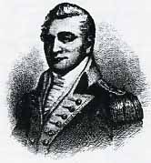
It would be illuminating to recount the illustrious names of the participants in the foregoing scientific venture, but we are interested only in the survey of the western boundary and the reasons for Beaver County's interest in it. Andrew Ellicott, of Maryland, had taken part in the completion of the southern line as one of Virginia's commissioners and was again appointed in running the western boundary. He later would survey and lay out the city of Washington, survey the boundary between the Spanish possessions and the southern states, the New York-Pennsylvania line and many other state bounclaries.9 Also acting for Virginia was Joseph Nevill, noted in Virginia, concurrently serving in the assembly, a little later in Congress.10 The Pennsylvania commissioners were Dr. David Rittenhouse, of the University of Pennsylvania (the College of Philadelphia) famous as a mathematician and astronomer, inventor of the famed orrery at Princeton (the College of New Jersey), and maker of the hand made transits used on the line." Associated with Rittenhouse was Colonel Andrew Porter (afterwards general), a distinguished Revolutionary officer of the Pennsylvania Artillery Regiment, a practical surveyor, astronomer and mathematician, once offered the office of secretary of war, and for a time, surveyor-general of the state. He named one of his sons, David Rittenhouse Porter as his associate in this enterprise. David became a two-term governor of Pennsylvania. Another son became secretary of war in President Tyler's cabinet. Another son, Robert, served in the Revolution in the artillery and attained the rank of lieutenant at the age of fifteen. He became president judge of the Third Judicial District, highly respected for his profound learning. Porter's great-grand daughter, Mary Todd, became the wife of President Abraham Lincoln.12
Ellicott, for the first 52.5 miles from the southwest corner of the state, acted for Virginia. After crossing the Ohio River, however, Virginia no longer was a party to the boundary line, having already ceded the land north of the Ohio to the Federal government.13 Beyond that point, Ellicott acted for Pennsylvania along with Rittenhouse and Porter.
In considering measurements of the line,
it should be borne in mind that the original (1785-1786) line
was run from the southwest terminal north for its full length
of 155 miles and 266 perches (rods), as Porter recorded,14 while
the re-survey (1879-1881, report dated 1883) was run from the
Lake Erie terminal point south to the north bank of the Ohio River.
15 This point in the meridian line is significant as the initial
point of the Geographer's Line, (so named for Thomas Hutchins,
Geographer of the United States,) which would serve as the base
line for the Old Seven Ranges of townships, (surveyed only south
of the line, since the meridian line north of the point would
not be finished until the next year. These townships north of
the line were not laid out until after 1800.)
It is not our purpose here to delineate this highly interesting
episode, since our present interest is directed to the boundary
survey. The reader is referred to the very able article narrating
the survey of the Geographer's Line in Milestones, Vol. 3, No.
4 (Autumn, 1977). At the time, this unpromising little project
to survey a straight line due west and from that to lay off rows
of six-mile squares, then to sell the land at public auction to
pay the debts of the Confederation Congress seemed sequential.
But few members of Congress--and fewer of the public--realized
the problems involved in employment of the principles of spherical
geometry to the practical application of them to terrestrial surveying.
Unrealized also was the public's want of interest in the rugged
terrain of the lower Seven Ranges. There were not found broad,
level acres where the forest could be burned down and immediately
planted in corn and wheat. Of greater interest and immediate value
was the survey finalizing the long delayed western boundary of
Pennsylvania so that land speculation and development could proceed
with certainty.17 No one foresaw that the inconspicuous beginning,
made in September of 1785, would proliferate and expand into the
rectangular system of public land surveys in all of the states
north of the Ohio and west of the Mississippi, excepting Texas,
but including Mississippi, Alabama and Florida, also Alaska."
The great land speculators like Robert Morris, the Nicholsons,
and the great land companies, the Holland Land Company and the
Pennsylvania Population Company could expand with assurance in
Western Pennsylvania. For the time being, the surveying activities
in the Seven Ranges only served to crystallize Indian resistance
among the western tribes which had not been included in the Fort
McIntosh Treaty. The Indian wars continued, with disastrous results
to the expansionists and federal armies, until General Anthony
Wayne's victory at Fallen Timbers (on the Maumee River in Ohio)
in 1794 and consequent treaty at Greenville, the next year.
Meantime, the survey of Pennsylvania's western boundary continued, although with a 12 month interruption, so that it was completed in 1786. The initial point of the Geographer's Line as carefully scaled upon the 1961 U. S. Geological Survey topographical map (photorevised in 1971) is located at 400 38' 21.710526" (may be simplified to 400 38' 22" North Latitude, at the very northeastern limit of the city of East Liverpool, Columbiana County, Ohio,- and that county, city and state share with Pennsylvania the honor of this historical and geographically important spot. Of course, Beaver County had abutted the meridian line of 11.41 miles from its meeting the present Washington County, prior to its reaching the Ohio River, thereby sharing the boundary conjointly with Virginia (the Virginia Panhandle, now West Virginia). The location is calculated at 400 28' 38.7" North Latitude, and 800 31' 11.5789" West Longitude.19
Colonel (afterwards Major General) Andrew Porter kept a journal of the daily progress of the survey. We shall note his pertinent entries during the time the party was engaged in surveying the line in Beaver County, in addition to his starting note and a few data given in the northward Drogress toward Lake Erie. 20
June 6th, (17851. Sent the axe men to cut the Western Boundary. [The axemen cut a swath 50 feet wide through the woods over hills and in important places to be viewed from the transit.
Near the end of his journal, Porter wrote that the surveyor, having reached the shore of Lake Erie, reported that the distance measured was 155 miles 266 perches (rods), or 155 miles 4389 feet, or 155.83125 miles. 21The "Chaining Notes of the Pennsylvania and Ohio Boundary Line Resurvey of 1881" record 91 miles 4650 feet as the distance from the Lake Erie terminus to the north bank of the Ohio River, or 91.88 miles. 22
The scaled distance of the Beaver-Washington County line south of the Ohio River is 11.41 miles. From these figures, we deduce that Beaver County begins at 52.54 miles from the southwest corner marker of the state. Porter's journal begins its most significant details in the near neighborhood of this very section of the line. It is worthy of notice that the stones erected to mark the line were native sandstone and were of uniform dimensions of 18 to 24 inches in length with 15 to 18 inches in height above ground, and 5 to 8 inches in thickness, the lower part sunken perhaps 24 to 40 inches deep, depending upon the nature of the soil. There were exceptions, as for instance, where a boulder was found buried deeply, under a roadbed, with markings. The stones were set longitudinally with the line, with P and V deeply cut into opposite sides, the corresponding initial letter of the state which faced the line. Sometimes a numeral was chiseled into the stone, denoting the distance, to the nearest mile, from the point of beginning.
11th. Moved and fixed the Instrument on a Hill some distance to the North not far distant from the 52 miles. Planted a stone on the hill marked P. & V. Moved the Instrument about a mile to the north near the 53. Planted a stone Marked P. & V. This afternoon Mr. R. and myself attended at the Instrument to give signals but the Vista being opened too far West nothing could be done. August 11, 1785.
11th. On this date, the transit instrument was brought forward within the limits of Beaver County. "Mr. R." means Dr. Rittenhouse.
17th. Moved and fixed the Instrument on a high hill near the 60y2 miles. Could find no stone to plant. Heavy rain about noon. Aaron Mills was struck with a tree, his thigh broken, lay senseless for nearly an hour. Set his thigh and carried him to the Virginia Camp. Moved our Camp by a very circuitous course, toward the East and found a tolerable easy descent to the River. Incamped near the banks of the Ohio, at the mouth of Mill Creek. This place is called Raritons Bottoms.
17th. The high ridge referred to above is Stewart Hill, near 1360 feet in elevation where the line crosses its summit. Aaron Mills was evidently a Virginia man, one of the choppers of the vista; not otherwise identified. This conveys some idea of the hazards of life in the frontier backwoods. "Raritan's Bottom," as spelled by Porter, is found as "Daniel Reredin of Washington County on the warrant for survey, dated January 18, 1785. On the draft ("draught") of survey returned August 18, 1785, the name appeared as Rearden's Bottom, but is endorsed "Reardons Bottom," Survey Book C, vol. 54, page 216. The patent, dated February 24, 1795, to one John Lee Webster is for "a certain Tract of Land called "Reardon's Bottom." This place was one of the important small forts to which General Hand, at Fort Pitt, sent a garrison of fifteen Continental troops, and an urgent meeting of officers from the frontier along the Ohio River was held there, in 1777. (See R. G. Thwaites and L. P. Kellogg, Frontier Defense on the Upper Ohio, Madison, Wis., 1912, 4: 44.; Survey and Patent Books, Bureau of Land Records, Harrisburg, Pa.) This land lay just above the mouth of Mill Creek and just below Georgetown, on the Ohio River. It is not mentioned either in Bausman's or Warner's History of Beaver County.
27th. Fixed the Instrument & Planted a large stone marked on the East side A Messrs. R., E. & Myself explored the Country for some distance to the North-Found the hills of Little Beaver almost inaccessible & after heading a number of little drains, got a high hill over which the line will pass- then turned to the Eastward to find some practical way of bringing our wagons forward. Found the Country level and the land tolerable good. A tremendous rain fell this afternoon, got to Camp, hungry, wet on the outside, dry inside.
28, Sunday. Went on horseback up the L. Beaver Creek & found it was possible to take our wagons up that course, proceeded about 6 miles north, found the Country level in general after leaving the main branch of the Creek.
27th-28th. A modern adventuresome excursion, which duplicated the exploring expedition of Messrs. Porter, Rittenhouse and Ellicott, is graphically described by Denver L. Walton in an interesting article entitled "Beaver County's Lock on the Sandy-Beaver Canal," in Milestones, volume 2, No. 2 (Spring, 1976). With his son, Walton nearly got trapped in the same entanglements of the rocky "canyon" of the Little Beaver that Porter and his party experienced. The Waltons, in 1976, evidently found an escape similar to that found by Porter, nearly two centuries earlier.
29th. Mr. Ellicott & myself went by water to Fort McIntosh. Our camp was moved forward near four miles.
30th. Returned from the Fort and lodged at Mr. Dorson's. The Instrument was brought forward near the Camp. From this place we have a view of the Vista for upwards of 7 miles back.
29th - 30th. The commandant, Lieutenant Colonel Josiah Harmar, at Fort McIntosh must have been pleased to entertain such a distinguished party of visitors. Benoni Dawson, of Montgomery County, Maryland, had been living at present Georgetown, opposite the mouth of Little Beaver Creek, since 1780. (A Warner & Company, History of Beaver County, Philadelphia, 1888, 561.) Porter rendered the name "Dorson."
5th. Corrected our Meridian the error was % of an inch east in 394 feet distance. Moved our Camp to the intersection of the Tuskaraway Path with the line.
6th. Moved and fixed the Instrument between the 5 & 6 mile-planted a small stone marked on the East side A Our present incampment is 7 1/2 miles from the River.
September 5th - 6th. The correction of 1/4 inch in 394 feet is computed to be I part in 18,912, which must be conceded a fine adjustment. For location of the point of crossing of the Tuscarawas Path see " 1764: Henry Bouquet's March Through Beaver County," Milestones, volume 5, No. 2 (Winter) 1979. The surveyors' camp of the 5th to 7th of September, 1785, was upon the ground of Bouquet's camp No. 6, in 1764, 71/2 miles from the Ohio River, by the side of Sheepskin Hollow Run.
7th. Moved and fixed the Instrument on a high hill at the 7 miles-from this place we have a beautiful view of the Vista for 4 miles the other side of the River and over several high hills to the north. The furthest appears upwards of 10 miles-planted a stone marked on the East side P. Doct. McDowell and Major Finney from Fort McIntosh paid us a visit.
8th. Moved and fixed the Instrument on a hill beyong the 8 miles. Planted a stone marked on the East side P. Major Armstrong set off for Fort Pitt to engage labourers.
7th - 8th. The high hill here described is Beatty Hill, just south and east of Bouquet's Camp, the highest hill between it and the river. The line stone Porter mentions was still in place a few years ago. The 1883 Re-survey Report mentions this marker as one having perfect alignment, by which others on the line were "made to conform." (Re-survey Report, 1883, p. 16-17, 55.)
This was a welcome visit by officers of the garrison at Fort McIntosh, just 131/2 miles and 48 perches distant from the fort, measured on the Tuscarawas Path (Bouquet's Road). (See Williams, "Robert McCready's Journal," Western Pennsylvania Historical Magazine, 43: p. 11 (1960.) Dr. John McDowell had served in the Continental Army from January, 1776 to the end of the war, November of 1783, both as a line officer and as a regimental surgeon. He reapplied for this service on the frontier in the United States service, resigning in 1788. He resided in Greensburg, Westmoreland County, after his service, until he died, in 1825. Major Walter Finney had a long service history in the Continental Army in the Revolution, from March, 1776 until November, 1783. He was captured at the battle of Long Island, August 27, 1776, and was wounded at Green Springs, Virginia, on July 6, 1781, in the battle of Lafayette's and Wayne's troops with the British army of Cornwallis. He was commissioned for this service in the United States Infantry on the frontier, August 12, 1784, and resigned September 1, 1787. (References to both of these gentlemen are found in Pennsylvania Archives, (5th ser.) vols. 2 and 3. Their service records are concisely recorded in F. B. Heitman, Historical Register of Officers of the Continental Army, Washington, D.C., 1914: McDowell, p. 368,- Finney, p. 227.)
The reference by Porter to the "hill beyond the 8 miles" would be Bliss Hill. It is obvious that laborers were scarce in this unsettled wilderness, so the logical place to seek them would be in the most populous locality, Pittsburgh. The Virginia laborers had been "paid off" when the surveying party had crossed the Ohio River. Just prior to that, the journal recorded that one man had been injured by a felled tree, and we shall soon see another.
9th. Opened the Vista to the 10 miles-Mr. Cross who was hurt by the falling of a tree on the 7th was buried this evening.
10th. Moved and fixed the Instrument on a hill at the 10 miles. Moved and encamped on the line West side of the East Branch of Little Beaver. Our incampment is 11 1/2 miles from the River. Opened a Vista about 1/2 mile North of the Camp on a hill.
9th - 10th. Porter has not mentioned previously that another man, whom he names Mr. Cross, had been injured by a falling tree, this time so seriously that he died. If he were buried near the camp, his grave would have been near the site of Bouquet's Camp No. 6. There have been rumors of a grave which was found in the vicinity, probably near the Bliss Hill site, only a half mile from the camp ground. The hill at 10 miles is Booth Hill.
The new camp site of the surveying party would have been on the northwest side of the North Fork of Little Beaver Creek, which crosses the state line a mile and a quarter east of Negley, Ohio.
11th, Sunday. Colonel Harmer and Major Doughty paid us a visit.
12th. Mr. Rittenhouse set off for Philadelphia. Gave signals and had a stake set on the hill where the Vista was opened on Saturday evening.
11th - 12th. Lieutenant Colonel Josiah Harmar, was Commandant of all of the troops of the army of the United States -- 202 by the last return, present and fit for duty. (Harmar to President Dickenson of Pennsylvania, from Fort McIntosh, June 1, 1785; Harmar Papers under that date, William L. Clements Library, Ann Arbor ' Michigan.) His Revolutionary record was long and enviable from 1775 until the disbandment of the army in November, 1783, under the most active commanders, including Wayne. Regrettably, he is remembered best for his defeat by the Indians in western Ohio, in 1790. (Heitman, Register of Continental Officers, 274.)
Major John Doughty was originally from New Jersey, but served as aide de camp to General Schuyler in New York and as an artillery officer under General Knox. He was commissioned to command the artillery in the artillery battalion of the United States at Fort McIntosh, where he arrived on September 7, 1785, and was almost immediately made commandant of the fort by Harmar. (See letter Doughty to Secretary Knox, October 21, 1785. Harmar Papers under that date, Clements Library. Heitman, Register of Continental Officers, 202.) He was sent to design and build Fort Harmar at the mouth of the Muskingum (Marietta) and in 1787 to Cincinnati to build Fort Washington. Doughty was considered a brilliant officer and served as lieutenant Colonel until 1800, when he resigned. He died in September, 1825. (Thomas H. Smith, The Mapping of Ohio, Kent, 0., 1977, pp. 71, 72, 81.) The mention of Dr. Rittenhouse returning to Philadelphia suggests that it was probably due to his duties there as treasurer of the state of Pennsylvania. He was a man of many accomplishments.
The departure of Rittenhouse brought Alexander McClean into the commission as associate of Porter. He had been appointed a deputy surveyor general of District No. 1 of the Depreciation Lands, which was contiguous to the meridian line; but, until that project would be finished, he could not begin the survey of the district. Hence, he was appointed to assist in the completion of the boundary.
16th. Planted a large stone marked on the East side P. near the Transit post on the hill 10 miles from the River. Moved and fixed the Instrument on very high ground at 13 miles. Moved Camp about 31/2 miles north. Heavy rain this afternoon.
19th. Planted a very large stone marked on the East side P/77 on the hill where the Instrument was fixed. Moved and fixed the Instrument 1 3/4 miles to the North-and again moved and fixed it some distance forward, in the evening.
16th - 19th. Having moved the camp 31/2 miles farther north on the line, the site of the encampment was a short distance northeast of the town of East Palestine, Ohio, about half a mile south of Ohio Route 14. This was the last campsite within the Beaver County sector of the Pennsylvania-Ohio boundary. It was also the last encampment in the year of 1785, for work was ended on September 23, and the journal was not continued until September 1, of the following year.
Having covered the 25.6665 miles of the boundary now shared by Beaver County with Columbiana County Ohio, the surveyors crossed the point which later would be the Beaver-Lawrence County line on Monday, September 19, 1785. Just 1445 feet beyond (north of) that line Porter noted that they planted a very large stone marked on the east side: P/77 which the re-survey team found buried under the Center of a road, now State Line Road, macadamized, north of Pennsylvania Rt. 51 (Ohio Rt. 14)
It is fitting to make acknowledgement of the courtesy of the Historical Society of Pennsylvania for permission to reprint parts of Pennsylvania Magazine of History and Biography, volume 4 (1880).- pp. 276-280, containing the reprinted parts of General Andrew Porter's journal.
1. R. G. Thwaites and L. P. Kellogg, Documentary History of Dunmore's War, 1774, (Madison, Wis., 1905), XIX-XX; E. 0. Randall, "The Dunmore War," Ohio Archeological and Historical Quarterly, 11 (1903): 178-9.
2. W. H. Egle, ed., Pennsylvania Archives, 3rd ser., 24: IV-VI, "Organization of Counties."
3. Thomas P. Abernethy, Western Lands in the American Revolution (New York, 1937), 91-2, 97, 227.
4. James Veech, The Monongahela of Old (Pittsburgh, 1858, 1892), 56. A concise and clear explanation.
5. J. F. Richard and T. Henry, eds., History of Beaver County, Pennsylvania, A. Warner and Company, publisher (Philadelphia, 1888), 550-1.
6. Thomas F. Gordon, The History of Pennsylvania (Philadelphia, 1829), 280-4; Abernethy, Western Lands, 10, 15; Williams, Fort Pitt and the Revolution, (Pittsburgh, 1978), 16-17.
7. Neville B. Craig, The Olden Time (Pittsburgh, 1846), 1: 448-453,
8. Veech, Monongahela, 257-9.
9. Pennsylvania Magazine of History and Biography (Philadelphia, 1877 - ...), 4 (1880): 266-267 (Hereafter cited as PMHB.) Catharine V. Mathews, Andrew Ellicott, His Life and Letters, New York, 1908. p. 107, quotes a letter of Simeon DeWitt, surveyor general of the state of New York, dated in 1795, in the Manuscript Dept. of the New York State Library, found in Field Book 35, Subdivision B, in which DeWitt states positively that there were, at that time, only two transit instruments in the United States, both hand made, one by Rittenhouse and the other by Ellicott.
10. PMHB, 4i 267 Veech, Monongahela, 134. Col. Neville (later a brigadier general of militia, was known in Virginia as a surveyor of many boundaries and rivers, a member of the Virginia assembly, later a member of Congress.
11. Dictionary of American Biography, 15: 630-32.
12. PMHB, 294.
13. Abernethy, Western Land, 272; C. E. Sherman, Ohio Land Subdivisions, Columbus, 1926, pp. 19-20.
14. Ibid., 42.
15. Report of the joint Commission Appointed by the States of Pennsylvania and Ohio to ascertain and re-mark the Boundary Line Between the Said States, Columbus, 0., 1883.
16. Sherman, Ohio Land Subdivisions, 42-43.
17. Ibid., 42.
18. Ibid., Frontispiece, map: Principal Meridians and Accompanying Base Lines Governing the Survey of Public Lands of the United States.
19. U. S. Geologic Survey Topographical Maps, Littleton, Cameron, and particularly those detailing the Beaver County, Pa., and Columbiana County, Ohio boundary line, Weirton, East Liverpool South, East Liverpool North, and East Palestine. Calculations are made from the 7.5 Minute Series, 1971-1976, Photorevised 1976-1978, and do not in all cases agree perfectly with early publication of latitudinal and longitudinal bearings, in minor differences of seconds. We are advised that these aerial surveys are correct.
20. PMHB, 4: 270-280. The Journal actually covers pages 261-285, but selections are made from the part that covers the action that occurred upon the Beaver County sector. In reality, the most interesting events took place there, of the whole survey route.
A somber note may be added that can only emphasize the stark reality of life in the wilderness, recorded by Ellicott of the same tragic event Porter noted upon the 9th of September.
' We have had several of our Workmen badly hurt by the failing of Timber on our Line - One unfortunate person by the name of Cross, was caught under the top of a tree last Wednesday, and died Friday the same night we buried him in the Middle of the Line, and raised him a monument of Logs - such a circumstance in the Wilderness, is attended with an uncommon degree of Solemnity-"
21. PMHB, P. 284.
22. Report of the joint Committee to Re-Mark
the Boundary, p. 58.