Click Here to Return to Milestones
Were its terrain to be graded, Beaver County would probably rate an average, middle of the chart score. Not that it is monotonous, it is in fact quite the opposite, it has a little bit of everything. The following excerpt will testify to that. It is taken from the SOIL SURVEY OF BEAVER AND LAWRENCE COUNTIES, PENNSYLVANIA; United States Department of Agriculture, Soil Conservation Service in Cooperation with The Pennsylvania State University, College of Agriculture, and the Pennsylvania Department of Environmental Resources, State Conservation Commission, by Robert V. Smith, Soil Conservation Service.
".. the northwest comer of Beaver County consists of undulating and rolling uplands, many poorly drained lowlands, rounded hills, and some steep ridges near the major streams."
"... and most of Beaver County is dominantly rolling and hilly uplands and many narrow, steepsided valleys. Here the level and undulating areas are mainly on the broad ridgetops and in river valleys.
Approximately 44 per cent of the land area in Beaver and Lawrence Counties is woodland, 34 per cent farmland, and 22 per cent is used for urban housing, industry, commerce, mining, and community serving purposes."
There are many very fertile meadows in Beaver County, and there are outcroppings of rocks and shale where watersheds have been eroding soil for long periods of time.
The great glaciers were also responsible for rearranging the countys topography and creating some strange effects. To get a description of Beaver County's geological background in as condensed a version as possible, we quote from the Beaver County Bi-Centennial Atlas.
"The native rocks underlying Beaver County were laid down some 300 million years ago. (During the Pennsylvania period of geologic time.) The materials originated as erosion products from a massive mountain range to the east, - the roots which lie in the British Isles and Scandinavia."
The rivers flowing westward deposited clay and sand, forming, in time, shale and sandstone in what would become Western Pennsylvania. Lush growths of wetland vegetation produced coal and petroleum, and during periods when the surface was depressed below sea level, countless billions of shellfish of every description contributed their discarded outer skeleton to form limestone beds. The heat and pressure created by the weight of the newer deposits changed the lower layers into consolidated and fossilized forms.
The birth of the Atlantic Ocean forced the American continent to separate from Europe and move westward. The east coast moved faster than the west, causing "wrinkles" in the surface rock which, after much erosion, remain as the Appalachian Mountains. Some underground ripples, notably the Homewood Anticline, extend as far west as Beaver County.
Floating on a sea of molten rock, the part of the earth's crust that was to become part of Beaver County was uplifted as part of the Allegheny Plateau. Erosion and the action of glaciers changed the plateau to it's present appearance.
In preglacial times, the rivers of Western Pennsylvania flowed northward into Lake Eric. The Monongahela flowed north through the present Ohio and Beaver Valleys, then through the
Mahoning and Grand River valleys to the lake. Another river rose below Moundsville, W.VA. and flowed north through Ohio and Little Beaver Valleys, joining the main stream near Wampum.
The appearance of the glacier in the north stopped the flow of these rivers, the wall of ice acting as a huge dam. For a long time, much of southwestern Pennsylvania was covered by what the geologists call Lake Monongahela, with only the hilltops showing above water.
In time, the accumulated water south of the glacier found a new route to the sea through the Mississippi Valley. The westward flow of the water resulted in a new river channel, which we know as the present Ohio River Valley.
The southward advance of the glacier ended, in Beaver County, along a line extending from Big Beaver (near Koppel) southwestward through South Beaver Township. North of this terminal moraine, the glacier changed the face of the land considerably, scouring off hilltops, depositing sheets of sand and gravel, and leaving much poorly drained land, swamps, and lakes by blocking stream movements.
South of the Moraine, the landforms were also considerably, changed. Glacial melt waters washed enormous quantities of sand and gravel downstream, forming the high terraces in the lower Beaver and Ohio valleys on which many of our towns are built.
Since the new outlet to the sea was at a lower elevation, rapid downcutting of the Ohio Valley occurred, changing the course of many tributary streams and forming waterfalls and deep gorges in many places.
The face of Beaver County continues to change today by natural forces such as flooding and erosion, but even more swiftly by the action of man. Highway cuts and fills, strip mining, dam construction, and changes in surface drainage due to housing development have affected the land in the few years of the 20th century nearly as much as did the glacier ten thousand years ago."
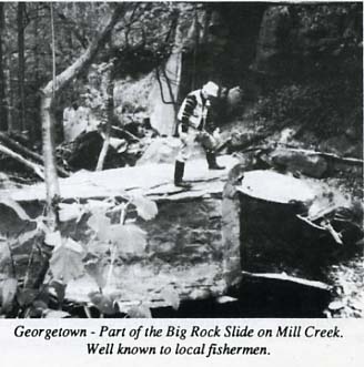
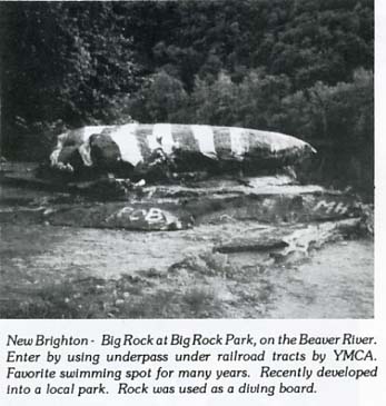
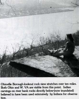
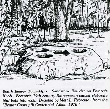
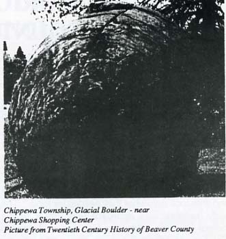
The end result of all this activity is that there are many unique rocks and strange natural rock formations scattered throughout our county.
The Indians used rocks as rallying and reference points. The early settlers also used them as landmarks. People developed such an affinity for some that they gave them names. Many of those names are still used today.
Our rocks may not have the fame of a Gibraltar, Plymouth Rock, The Great Stone Face or the Natural Stone Bridge. But we do have interesting legends and antidotes about many of them.
Others are just here, doing what rocks do best - defying time - existing silently and mysteriously.
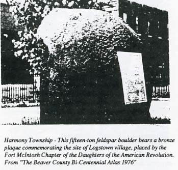
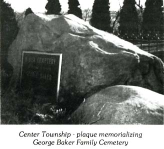
Some of the rocks are still exactly as the forces of nature had left them. Others have been embellished by men with plaques to commemorate something or someone. Some have been moved to put them in a more dramatic location or position. And, much to our dismay, some have been desecrated with graffiti, and paint.
Pictured here are a few of the better known rocks. Undoubtedly there are many that we missed. If enough are brought to our attention some day we can possibly do a sequel to this article.