Click Here to Return to Milestones
Editor's Note--The following geographical
descriptions are based on two local Sam Brady stories.
The first concerns a contested story of
Brady being captured by Indians and then tortured in the Brady's
Run area. Before he can be dispatched, so the story goes, he grabs
a baby from a squaws arms and throws it into the fire. In the
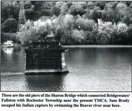
ensuing confusion, he escapes and swims across the Beaver River
to safety.
The second incident is dated from March 9, 1791. An Indian raiding party ravaged the home of Francis Riley, killing six people, including two infants. Brady led a party of rangers, including Lewis Wetzel, on their trail. They catch up to Indians above the mouth of the Beaver River. In the following battle, eight warriors and a squaw are killed.
Beaver County is redolent with the Brady
name, now unfortunately submerged under the blanket of modern
history and the politically correct revisionism and distortion
of our historic roots. But we still have Brady's Run, Brady's
Run County Park, Blockhouse Run, and a more publicized existence
of Fort McIntosh, all of which spring from generally the same
time frame, and are planted clearly and squarely on maps of my
home county, Beaver County, Pennsylvania.
I have lived here for 65 odd years, have
swum, illegally, in Brady's Run Lake and run, legally, on the
Conrail Tracks, Route 51, and Darlington Road, and the juncture
of these three forms a fair location for the two Brady adventures
considered here. So, for 35 odd years I have run at least weekly
within 300 feet of the sites discussed below, and I hope the reader
forgives these personal matters, but it is the very force of these
historic happenings that hammers in my brain as I run. These have
driven me to probe a little deeper into local records, particularly
after reading Eckert's, That Dark and Bloody River.
Sadly, no historic marker has ever been
placed regarding these events, save a bronze plaque memorializing
the Big Beaver River Blockhouse. Instead, Conrail now owns the
right of way down the west bank of the Beaver River. Pennsylvania
Route 51 has come down the valley of Brady's Run, and likely some
of the fill of its building has been pushed onto the Brady sites.
However, these two runs, and the exploits described, give us fair
information that allows a credible attempt at locating these events
in the terrain as it presently exists.
Thus, the purpose of this article is to
locate, as nearly as possible, the site of these two events, not
describe them in detail. However, I must refer to them to make
my case, so the earlier (1783?) event [will refer to as the "Fire"
event, and the later, March 9, 1791, I will refer to as the "Raiding
Party" event.
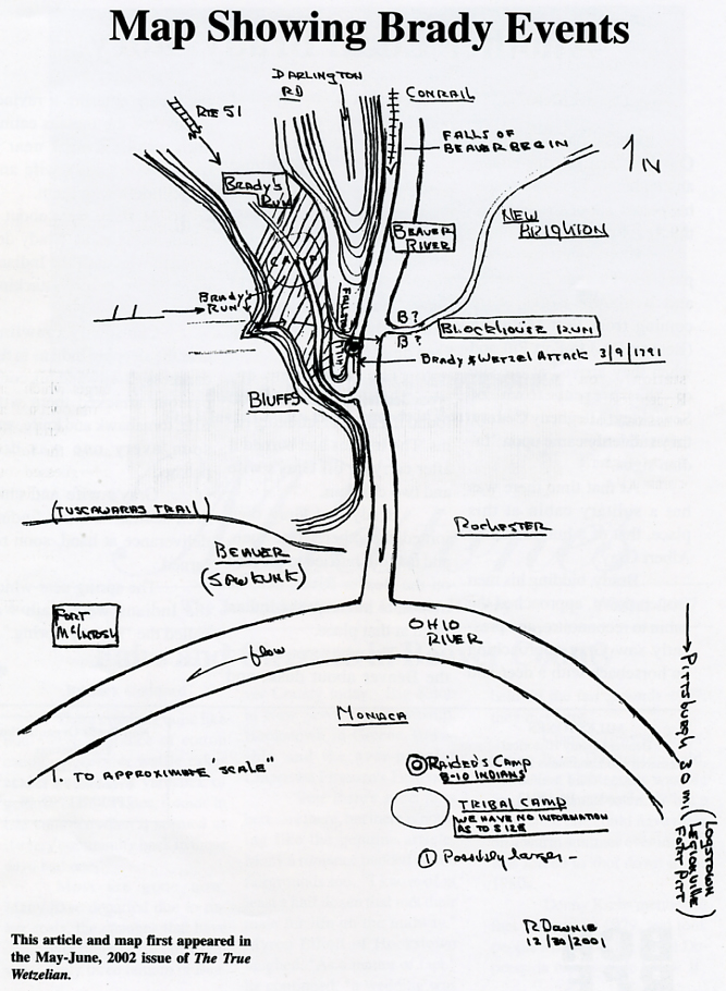
Consider first, then, that the four remaining
geographically fixed features of each - Blockhouse Run, Brady's
Run, Fallston Hill, and the Beaver River still stand relatively
firm, despite railroads, dams and the human race, and all four
can be encompassed in a circle of a half-mile diameter. Next,
note the "nose" or protrusion of Fallston Hill as it
descends to the south, Brady's Run to its right, the Beaver to
its left. This is the southern extremity of one of the long, fingered
"ridges" that gird the Beaver River; this particular
one (on which I've lived for a score and more years) looms over
the Beaver River for two miles upstream from the site which concerns
us. But the "toe" of the slope, as it drops toward water
level, forms a low ridge or hill that lies between Brady Run Valley
and the Beaver River Valley. This is featured in the Raiding Party
account, in which Wetzel's group came over the hill, and Brady's
group up the river bank to attack the Indian camp from the rear,
as it were. Next, note that Blockhouse Run enters on the east
side of the Beaver, almost directly opposite the toe of the slope
of Fallston Hill, and Brady's Run enters the Beaver on the west
side, perhaps 100 yards downstream from Blockhouse Run. Also note
that, as one ascends Brady's Run, the valley is narrow and doesn't
widen out for several hundred yards upstream from the Beaver.
Now the Indians give us a message; from accounts of Indian life from firsthand observers such as Heckewelder, Zeisberger, and Weiser, it appears that the Indians tended to camp on flat ground, close to water, and as secluded as possible. This illuminates the Fire account, in which Brady, stripped naked and sentenced to burning and torture, seized an Indian child and pitched it into the fire, creating the diversion that allowed his escape by running up a very steep bluff. The campsite is likely the first "flat" upstream; note that this site is barred from the view of the blockhouse by the toe of Fallston Hill, rendering it even more likely as a choice by the Indians, who did not want to draw the attention of whites. We know nothing of the size of the camp, save that it was likely 6 to 12 lodges, for the Indians tended to see the burning-torture of their captured foes as a local Super Bowl, and tried to include as many as possible in the ceremony.
Then recall that the blockhouse was obviously
near enough to the run named for it to appear in both accounts,
for Brady swam to it for safety in the Fire incident, and the
owners of the blockhouse, William Wilson and John Hillman, figure
in that latter story. The Indian party was camped across from
it in the account of March 9th, 1791. Even though we aren't certain
which bank of the run the blockhouse was on, we can nonetheless
project a 300-foot "corridor" across the Beaver from
it, centered on the creek mouth, which then strikes the west bank
at the area between the end of Fallston Hill and the opening of
Brady's Run into the Beaver. If this imaginary corridor is projected
to the western hill line (indicated by Bluffs on the map), it
will then locate for us significant events of the Raiding Party
event and the Fire event.
Here my personal observations come into
play. Ironically, a regular running route of mine is to come south,
either down Route 51, or down the Conrail tracks on the other
side of the ridge, next to the Beaver River. I then hit my pivot
at a point within 100 feet of the juncture of Brady's Run's with
the Beaver, and run north up Fallston Hill, the site of the Raiding
Party event on my right (where Fallston now lies) and the Fire
event on my left, where businesses such as "Shooter's Place"
now reside down in the valley. Weirdly enough, "Shooters
Place" is in a little strip mall built on fill just west
of Route 51, and it could well be exactly on the spot of the Fire
event. Included in its stock are flintlocks and black powder supplies,
so I think Brady would be forgiving of this obscuring of his life
story. Lastly, note that a little ravine cuts into the Brady's
Run Valley from the west, wider at the bottom, narrower at the
top, and which lies almost directly opposite Blockhouse Run on
the east bank of the Beaver. The hills in these parts run from
300 to 400 feet above the valley bottoms below them.
Now to the conclusions: Brady's Fire event
says that when Brady was captured, the Indians took him "a
mile and a half" up the Beaver and up the run coming in on
the west bank. That's about right, for Brady's Run is a little
more than a mile above the river mouth. Then, in his escape, he
"ran up a steep hill behind the camp," eluded pursuit,
and then managed to get back to the Beaver River where, undetected,
he swam across to the blockhouse. In other words, he doubled back,
did a 180-degree turn, and passed the camp without being seen.
How did he do this?
What the terrain discloses, I think, is that Brady, stark naked
and unarmed, remember, skinned up the bluff. It can be done -
I've done it, and then cut south a hundred yards or so into the
"little ravine." Thus shielded from view from the camp,
he descended the ravine and then moved through the brush to the
Beaver River. This area gets from 38 to 48 inches of rainfall
per year, and creek bottoms can easily turn into jungles of sumac,
blackberry, and understory, growing four to six feet high; good
cover for deer and any other creature, and perfect cover for an
experienced woodsman like Brady. Thus, I argue that the Fire event
occurred within the circle marked "Fire" and the small
ravine indicated by the arrow and footnote on the sketch.
The Raiding Party account states that the fleeing Indians camped
"across from the blockhouse," and that, when they were
discovered, had "a low hill" behind them. So they were
camped between this low rise and the Beaver, and across from the
blockhouse. This "hill" is obviously the slope of Fallston
Hill. Railroads have a bad habit of filling in low spots, so I'm
guessing that the P&LE, predecessor to Conrail, filled the
spot of the Raider's camp, but in walking the area, it's easy
to see that the ridge of Fallston Hill veers a bit from the Beaver,
leaving flats on the river side adequate for the Indian's camp,
and as well, lying in or very near to the 200 foot corridor set
by the blockhouse.
Incidentally, the plaque notes the existence of the Big Beaver
Blockhouse that apparently had an Army garrison of 19 men. The
map is my doing, and is a schematic tracing - not drawn to scale,
made to illustrate the points made above. I have omitted a lot
of recent "clutter" for the sake of clarity, but have
footnoted the location of major contemporary features, in case
the reader would like to examine the terrain.
While both creek mouths are visible from a boat run up the Beaver, I wouldn't advise It. Its depressing to me to see water skiers and pleasure boats on water of such historic value. And railroads and highways have covered the creeks with concrete culverts. On the other hand, the Beaver carries walleyes and bass, which, being wild things, compensate a little for the encroachments of civilization, and you can, with a walleye on your line, wonder at these strange happenings of history.