Click Here to Return to Milestones
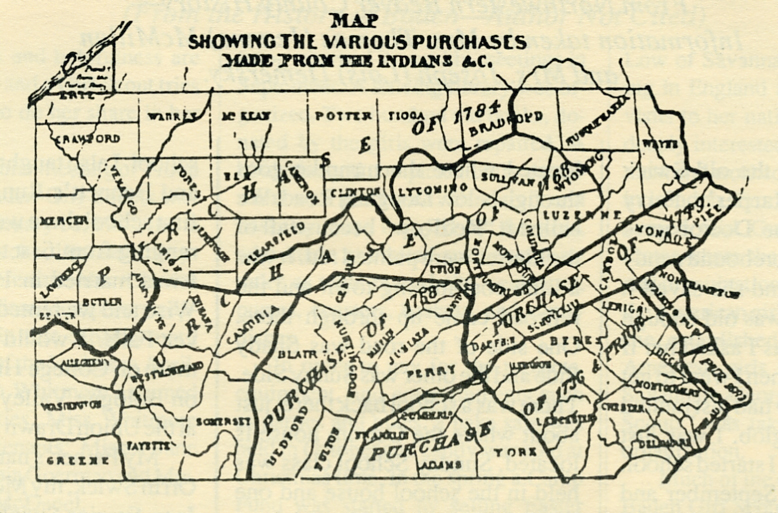
"One hundred and five dollars and eighty-three cents." That was the price tag on all the land of Beaver County north of the Ohio River, the first time it was sold. Actually, it was part of a much larger purchase involving 13,550 square miles and including nearly one-third of the present state of Pennsylvania.
Based on the early English claims, the first owner of what was to become Beaver County was James, The Duke of York, and brother to King Charles II. The title to the land passed to William Penn by charter from the king, and by deed from the Duke of York, and thus, in 1682, the province of Penn's Woods, or Pennsylvania, was established.
But Penn was a most honorable man, and recognized the claims of the native Indian tribes to the land which they had long occupied.
Unlike many of the other colonies and provinces, where the Indians were put off their lands without compensation, Penn began a long series of treaties with the natives to transfer possession of the lands to the satisfaction of both parties.
Blankets, needles, knives, axes and guns were the medium of exchange. These items were useful to the Indians, but in time they realized that they were being poorly compensated, and occasionally they were paid twice. The entire state was thus bought for a few thousand dollars worth of trade goods.
Beaver County was first involved in the treaties in the Purchase of 1768, when an agreement with the Six Nations transferred ownership of avast area of the province to the Proprietary Government, headed by John Penn (grandson of William). The South Side of Beaver County was included in this deal.
The land was not yet occupied by permanent settlers, (not for four years, in 1772, when Levi Dungan built a home at Frankfort Springs) and was an endless wilderness, but the dealings with the Indians were overshadowed by a more serious claim to our part of the forest.
The Colony of Virginia had long interpreted her charter to include all land south of the Ohio River. This claim ran head-on into that of the Penns in Southwestern Pennsylvania. A compromise agreement was finally reached in 1770, resulting in the present-day West Virginia panhandle, but that's another story.
Who were the Penns dealing with in these land transfers? Ignorant savages, living like animals in the woods? Not exactly. The Indians of The Six Nations were called "Mingoes" by the English and "Iroquois" by the French. They considered themselves to be more civilized and cultured than any of the white invaders, but theirs was not a material culture, and whites to this day cannot see them as more than primitive savages.
The Iroquois were not the main occupants of Beaver Valley, but the local tribe of Delawares, like many others, was subject to the authority of The Six Nations. Thus the Delawares (and neighboring Shawnees) were not consulted when the lands were sold.
A look at a map of the Finger Lake region of New York shows that the western most tribe was the Senecas, who occupied much of the western New York and Pennsylvania. Adjacent to the long lake named for these people is another named for the Cayugas. Lake Onondaga, near Syracuse and Lake Oneida, the thumb of the Finger Lakes, also bear names of the Six Nations tribes.
The name of the fifth tribe, the Mohawks, lives on in the Mohawk River, whose valley cut through the Appalachian chain to create a pathway for the pioneers. The sixth nation, the Tuscaroras, had migrated southward to the Carolinas in prehistoric times. Upon their return north, they were welcomed back into the Iroquois "Ionghouse."
So it was at Fort Stanwix (later Rome, New York) at the headwaters of the Mohawk River, where representatives of Pennsylvania and the fledgling United States Government met with Six Nations leaders in 1784, just after the close of the revolution.
Pennsylvania was a state, now, and eager to settle the last remaining question of title to her land. The treaty was made and signed, and the last legal claim of the Indians in Pennsylvania was extinguished.
Three commissioners represented the United States Government, including General Richard Butler (Revolutionary hero for whom Butler County is named). Pennsylvania was represented by Samuel Attlee, Francis Johnston and William McClay. Signing for the Six Nations were Ojistarare, Chief of the Oneidas, and 13 other chiefs including Oraghgnanontagon and Keatarondyon. The Indians were not burdened with remembering how to spell their names, for each signed the treaty with his own picture-mark. The English spelling of the names was recorded for posterity by the missionary who served as interpreter, Samuel Kirkland.
Thirteen thousand, five hundred and fifty square miles were surrendered by the Indians for $5,000. This amounts to 37 cents per square mile, or 17 acres for one cent. Fourteen present-day counties were created from these lands, and parts of nine others, including Beaver County north of the Ohio River.
Beaver County was yet to be conceived, but the portion of the purchase price covering the land within present-day boundaries was $105.83. Not a bad price, but how would you like to pay property taxes on what that land is worth today?