Click Here to Return to Milestones
I was born in "Constantinople."
I learned this fact only recently, and it came as quite a shock not only to myself, but to others' involved in the incident. A second surprise came when I discovered that I've been making my living for years at a place called "Naiad's Delight"!
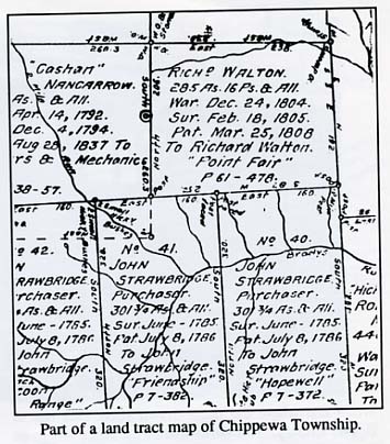
The revelation came when Bill O'Neill, Beaver County Recorder of Deeds, showed me a set of maps in his office. The maps are copies of originals on file in the Land Records Office in Harrisburg, and they were compiled from records of the early surveys of the Beaver Valley when there was no Beaver County and raids by renegade Indians were a constant threat.
Divided roughly into present-day townships, the maps show the survey lines and approximate location of each tract. Also shown are the names of the warrantee and patentee for each tract. In brief, the warrantee was granted the tract of land in return for, in most cases, service in the Revolutionary War.
Due to the unsettled nature of the frontier in the 1780's, and also for a variety of personal reasons, the warrantee may have decided not to claim his warrant, but to sell it instead. Many tracts on the maps thus show a second name, that of the purchaser or patentee, who was actually the pioneer settler on the land.
Most interesting, though, is the fact that many of the tracts, perhaps three-fourths of them, were given names by their owners. Some of the names are colorful and imaginative, and were borrowed from history, geography, literature and mythology. Others simply reflect the names of the owners, such as "Hopson's Choice", now in Independence Twp. and "Barnet's Claim" now in Hopewell Twp.
With an up-to-date map of Beaver County as a guide, an exploration of the early land survey maps is sheer delight. First of all, the tract of land named "Constantinople" lost its identity over the years, and is now part of Aliquippa (and includes that little comer of the world known in recent years as Plan 12.)
A grand tour of the Aliquippa area takes us to a number of tracts with exotic names ... (Some of the spellings seem strange, but spelling wasn't very consistent back then, even among those who could read. And most of our pioneer settlers probably couldn't!)
West Aliquippa was originally "Banna's Banks" while New Sheffield was "Oak Flat." The old stone arch area is at the center of "Bloomsberry" which includes Linmar, part of Sheffield Terrace, and Green St. 'Me rest of Sheffield Terrace was "Greenwood." Downtown Aliquippa consisted of several small tracts which weren't named.
The Hollywood section of Plan 12 and the hills to the south were in "Alexandria." Aliquippa Hospital is on a tract called "Fruitful" while the Country Club area was once known as "Bruce's Swither." The new Hill's Shopping Center is located on several tracts, two of which were called "Charybdis" and "Caledon."
The Brodhead Rd., leading south through Hopewell, passes through "Aberdalzy", "Sherboum", "Bunhill Row", "Shrowsbury" (at Five Points), "Islington" and "Highgate." It just misses "Gomorrah" (Gringo Rd. and Clearview Estates).
The largest claim stretches from Gringo west to Bocktown and Independence. Called "Simm's Choice" it was surveyed on a military warrant by the State of Virginia in 1785, when the statehood of the land south of the Ohio River was in doubt. A few other Virginia claims are recorded, but most were Pennsylvania warrants. (The present boundary was established later in 1785.)
The stretch along the Ohio River north of Flaugherty Run which includes Glenwillard, Wireton and South Heights today, was originally surveyed as three tracts named "Shedrack", "Meshack" and "Abednego."
In present-day Monaca, we find that the first landowners called their property "Appetite" (west of the toll bridge) and "Walnut Bottom" (east of the toll bridge to Colona).
The Beaver Valley Mall rests partly on a tract called "Rasberry." St. Joe Zinc is located on two pieces once known as "Sterling" (east of Rag Run) and "Catt's Can", the main plant. The ARCO Beaver Valley Plant was "Naiad's Delight". The east side of Raccoon Creek, site of BASF Building Products, was "'Me Contest".
The names of the early land-owners offer clues as to the origin of many present-day place names. "Green Garden" was an early tract name that stuck. And "Gum's Run", long a mystery to many local historians, was obviously named for either Hannah or Abraham Gum, each of whom owned land nearby. A tract in Center Twp. called "Elkhorn" lies at the headwaters of present-day Elkhorn Run.
Thc variety of names in Raccoon and Independence Twps. range from cautious optimism: "Prosperity" and "Good Luck" to the sublimely ridiculous: "The Asses Head" (on the County Line, where Hopewell and Independence come together).
Many of the tracts were named in recognition of the earliest inhabitants: "Owl's Nest", "Panther's Grove", "Rabbit's Resort", "Fox Chase", "Bear's Lament" and "Deer Park."
Many were named for their owners: "Redicksburg", "Irwin's Grove", "Joseph's Park." Others are completely incomprehensible: "The Barrier", "Peek of Ree" and "Delay." There is one, though, that just might become a popular place to visit, but I don't think I'll tell you the exact location of "Cupid's Haunt."
It will soon be time to run out to "Encouragement" and set up our trailer for a weekend of camping. While we're there, we may decide to hike through "Squabblefield. " If things get too dull, we could drive down to "Triple Attack" for a Coke, or look for wildflowers in "Pleasure's Step" or "Beargrass."
You guessed it. We're in Raccoon Creek State Park, and these are the names of the early land tracts bestowed by their first owners as far back as 1785!
"Triple Attack" is present-day Frankfort Springs, and to get there we must drive through "Bachelor's Hall," named by warrantee Levi Dungan, who with his wife, Mary, is generally recognized as the first permanent settler in Beaver County.
The early surveyors in Hanover Twp. seem to have been at war with each other, for many of the tracts overlap, and many odd little comers were left unsurveyed and unpatented until as late as 1865.
The Green Twp. area provides us with some of the most colorful tract names of all I've seen. The delightful old rivertown, Georgetown, lies on a tract called "The Bone of Contention," while Shippingport occupies "Witheroes Flatt" and "Fellinghousen" (Remember -the spelling was theirs, not mine).
"The Whiskey Mill" is the north side of Hookstown, while "The Oblong" is part of the south side. Right in the middle was "Harrymount," an eight acre triangle belonging to one Henry Hooke. And just to the east was the property of Matthias Hook, called "Hook and Crook."
Another notable early resident was Andrew Poe, who live on "Poewood." We cannot leave Greene without noting a thousand acre Virginia warrant called "The Monster."
Looking around the Valley, we find that the south end of Ambridge and Fair Oaks was called "Picardy." The rest of Ambridge is located on "Partnership", "Lawrences' Retreat" and other tracts. The Harmony Twp. section along the river included "Mount Pleasant" and "Antwerp." This land was purchased in 1824 by the German-speaking Harmony Society, who had little knowledge or regard for English and probably forgot the tract names before the ink was dry on the deeds.
Baden of today was called by its original owners "Lancaster," "MacKean," "Sullivan" and "Cuthbert." Northern Lights rests on a tract named "Wayne" which reflects the stopover of Anthony Wayne's Legion in 1794, though it's a little to the north of Legionville. These names have all disappeared.
To the east, Economy occupies a variety of tracts ranging from "Happy Ville" to "Fatland." One tract sounds familiar, though. The Golden Grove Road takes its name from a land tract, "Golden Grove" on the Allegheny County line.
Rochester, Bridgewater, Beaver and Vanport were once part of a large piece of land called the "Reserve Tract" (which was identical with the boundaries of Beaver Borough when it was first incorporated.) The history of the "Reserve Tract" is another story, but I'll just note here that no individual tract names were bestowed upon this section.
I'll conclude with a quick tour of the upper Beaver Valley. Fallston was once "Alammelech" (on the river) and "Good Intent" (on Bradys Run). Patterson Heights was "Friendship" while Beaver Falls was "Stockwell" and "Hillsborough." The tract comprising Morado and Gaylord's Department Store was "Battle Ground."
New Brighton (and Pulaski, to the east) was "Lukens Villa," "Roxborough," "Bradville" and "Mercer" (Mercer Road?). Eastvale was "Saratoga." Homewood is located on a tract called "Stratton" while Koppel is on "'Me Raccoon's Dwelling." New Galilee on part of a tract called "Chapman's Hall," while Darlington was part of "Sproat's Delight."
I've given you but a sample of the many
hundreds of names of the original land patents in Beaver County.
Anyone seriously interested in local history will want to see
the maps themselves in the office of the Recorder of Deeds. And
I hope you find them as much of a delight as I did.