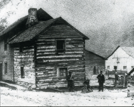
This log house stood in Brady's Run Valley and was the home of Sylvia Fay Casey. This could well be the house that Ned Weber refers to in the article.
Click Here to Return to Milestones
There have been so many changes that have taken
place in our country over the past century. One of the most notable
with the increase in our population has been the transition from
a rural to an urban and suburban society.
As one who has lived all of these years except the first seventeen
1, as others, have witnessed many of these changes that have touched
our lives.
Brady's Run Valley was a rural area and boasted only dirt roads.
I recall only one habitable home in the area extending from Fallston
borough to the present Route 60 bridge. There was no road in the
valley connecting the current Route 51, known as Constitution
Boulevard, west from the traffic light at the main entrance to
the park at the Ice Arena to Chippewa Township where it intersects
Route 60.
One access to Brady's Run in those days was by way of Beegle Hill
which extended from Fifth Street on Patterson Heights across old
Darlington Road and behind the former Beegle estate known as "Heath
Manor" (currently the site of Franciscan Manor, assisted
living facility) to the valley below at the main entrance of the
current park. This road also extended along the base of the hill
at the rear of the current trailer park to the bottom of Fallston
Hill on old Route 51, providing another access from that area,
The flat area to the south of the current main entrance was reported
to be a training ground for soldiers during World War I although
no evidence of that remained in the years to follow.
The Brady's Run area generally extended from Coal Pit Hollow Road
(or First Hollow), now designated as Wildwood Drive near the south
end of the valley to the Box Canyon site of the current rifle
range at the northwest end which was named Third Hollow. In the
area near the current rifle range was the location of Jack Lee's
cabin inhabited by a person who obviously enjoyed the basic life
style.
Second Hollow was our designation for the developed area extending
from the main entrance of the park to the area of the current
Route 60 bridge.
Bridges over Brady's Run were designated as the First Iron Bridge
at the main entrance, The Second Iron Bridge to the current Horse
Arena and to the hill, leading to Dutch Ridge Road (now closed)
. The Third Iron Bridge was located at the western end of the
park at the upper end of the lake, near the large Number 1 picnic
shelter.
We had several swimming holes that we frequented with names, such
as The Forks where the two branches of the Run met, just south
of the Ice Arena; Four Foot about 100 yards south of The Forks;
another we called "Where the Fishes wear Glasses", when
one of the group lost his glasses and they were never recovered.
The most noted spot of all, however, was Henny Heeson's, named
for a local man who developed it. This swimming hole was located
about the center of what is now Brady's Run Lake and due to the
now existing dam and water level was accessed several feet below
the current road. A diving board was a feature which added to
our pleasure.
One of the unique memories was the abandoned two-story log house,
located between the main road and the run just south of the bridge
to the Horse Arena and the current recycling center. (It may have
been that portion of the home shown on page 151 of Beaver County
Album #1 by Arnold McMahon and Denver Walton.) We referred to
it as the Haunted House. There was also an abandoned deteriorated
two-story frame house located at the bottom of the previously
mentioned Beegle Hill.
Many hours of pleasure were experienced by the youth and families
of this undeveloped pristine area in that period of our lives
prior to the construction of Route 51(Constitution Boulevard)
through Brady's Run and the development of the park after WWII
for the enjoyment of many today.