Click Here to Return to Milestones
Before the airplane, before cars and trucks, before the railroad, Beaver County depended on waterways for transportation. At first it was flathoats and keelboats on the Ohio, floating down from Pittsburgh. Then, very early in the county's history, came the steamboat. Beaver County was not only to benefit from the steamboat, but to build a great many of them.
But rivers don't always flow the way people want to go, so a man in New York named DeWitt Clinton built a canal from Albany to Buffalo, and it was enormously successful. Before long, all the states in the Northeast were building canals, especially Pennsylvania.
Beaver County had two canals. One of these was very influential in helping the county grow and develop. This was the Beaver Division Canal, the lower part of the Beaver and Erie Canal. The other one became just a footnote to history, the Sandy and Beaver Canal.
The Beaver Division was built to carry Pittsburgh traffic north to Erie, to keep trade in Pennsylvania, but it also carried Lake Erie traffic (from New York's Erie Canal) down to the Ohio River. Countless emigrants to the west travelled this way. It was completed in 1832 and began at Rochester, stretching north to a point above New Castle called Harbor Bridge, a distance of 31 miles, where it joined the Erie Extension Canal to Erie. There was one important branch. At Mahoningtown, south of New Castle (and until 1849, part of Beaver County) the Pennsylvania and Ohio Canal branched off, heading to Youngstown, Warren, and Akron, where it joined the Ohio and Erie Canal. Nothing is left of the P and 0 Canal in Pennsylvania today.
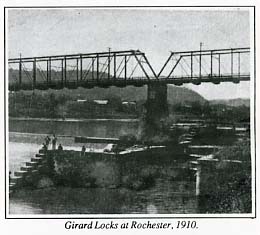
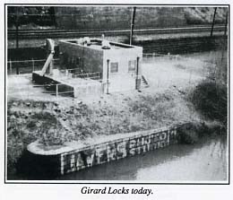
There were 17 locks on the Beaver Division, nine of them in present day Beaver County, and six dams. A lock is a stone chamber with wooden gates used to raise boats from one level to another, usually adjacent to a dam. A typical lock on the Beaver Division lifted the boats about eight feet. The locks were numbered south from New Castle, so the two at Rochester were numbers 16 and 17. They were called the Girard Locks, for a Philadelphia financier who invested in the canal, and were larger than the other locks, big enough to pass small steamboats.
The Girard Locks remained in a good state of preservation until about 20 years ago when a sewage pumping station was built on top of them. The outer wall can still be seen. The stone abutment for dam no. 6 can be seen on the Bridgewater side.
Locks 15,14,13, and 12 were a flight of four at the lower end of New Brighton, each about a city block apart. They existed until 1926, when the Pennsylvania Railroad changed its route through town to the riverbank and covered them up. They were called, moving north, the Blount Lock, Boyle's Lock, Buck Woods' Lock, and Van Lear's Lock. The origin of these names is obscure, except that there was a canal boat captain named Jack Boyle.
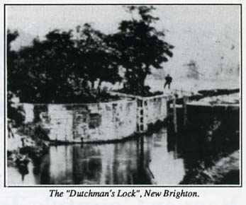
None are visible now except for the river wall of the Blount Lock, which can be seen quite clearly from the Fallston Bridge. From the four locks, the canal proceeded in its own channel to the Beaver Falls Dam, (originally dam no. 5 on the canal) where the Dutchman's Lock (no. 11) was located. The existing east abutment of the dam may be the river wall of the lock.
The canal proceeded north in the river channel, called slackwater, to Eastvale, where there was another dam (no. 4) and a short stretch of canal with two locks. These were the Bannon and Farrow Locks, nos. 10 and 9. Bannon was another canal boat owner. A large pile of stories on the river bank shows the site of one of these locks, and drill marks in the native rock show where the canal was cut into the bank. From here the canal proceeded north again in slackwater, this stretch being called the Seven - mile level.
The next 1ock (no. 8, dam no. 3) was at Rock Point ,just north of the county line. Here the lock site is quite evident. This was the location of the Metheny Tavern, a notable landmark on the canal and later a railroad station. Part of the tavern foundation can still be seen. It was here that James Garfield, as a young canal boat hand, nearly drowned in the Connoquenessing Creek. (But that's another story.)
Upstream locks, now in Lawrence County, were at Staylesville (no. 7), West Pittsburgh (nos. 6, 5, and 4), Mahoningtown (no. 3), and New Castle (nos..2 and 1). At Big Run, just north of lock no. 2, there was a stone aqueduct. Piers supporting the present railroad bridge look too massive for that purpose. I suspect they are the original aqueduct piers. Nothing remains of any of these northern locks. The canal at New Castle crossed Neshannock Creek at water level, crossed the city to the west and passed into the Shenango River. Upstream five miles the canal joined the Erie Extension Canal.
Canal authorities like to state that the Beaver and Erie Canal was a failure in that it didn't pay for its construction and upkeep. It certainly did not fail to give a tremendous boost to the growth of the cities and towns along its route.
The Sandy and Beaver Canal was another story. Completed in 1848, the Sandy and Beaver was intended to improve the economy of the farms and villages along its route. Starting in Glasgow, PA (in Beaver County) it followed Little Beaver Creek to its headwaters near Lisbon, OH, then westward across a summit level to the headwaters of Sandy Creek at Kensington. It continued west to Bolivar, OH on the Ohio and Erie Canal along the Tuscarawas River. The canal closed in 1852, only four years after completion, much to the chagrin of the local farmers who invested heavily and donated land for the canal. The eastern end of the canal, near the Ohio River, lasted a few more years but it too was doomed to early failure.
There were only three locks in Pennsylvania, nos. 57, 56, and 54 (locks were numbered downstream from the summit level near Lisbon). Lock 57 was at the end of Liberty Street in Glasgow, Lock 56 was along Beaver Creek a few hundred yards Upstream. Nothing remains of these two locks. Lock 55 was in Ohio, following the creek as it meandered across the state line. Finally, Lock 54, in an excellent state of preservation, lies on the west bank of Beaver Creek, but is in Ohioville Borough. The lock is well worth seeing but it is in the most inaccessible spot in the county, requiring several miles of hiking through some of the roughest country imaginable. I hiked in with my son seventeen years ago and I hope to do it again soon.
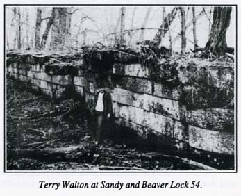
Much remains of the Sandy and Beaver in Columbiana County, OH, especially near Beaver Creek State Park, But Beaver County can claim one isolated lock, however hard it is to get in to see it.
So this is the story, briefly, of Beaver
County's two canals, and of the villages along their route, and
of what remains to be seen today.