Return to Milestones Vol. 4, No. 4
Board of Canal Commissioners of Pa. Gentlemen:
I have completed my examinations and surveys on the Beaver Division of the Pa. Canal, and herewith present to you my plans and estimates.
Betwixt New Castle and Clarke's Mills, a distance of 5.77 miles, the banks of the streams are generally too low to admit of Slack water navigation without overflowing the adjoining flats, and endangering the health of the country. Upon this portion of the line therefore I have located a Canal, which I propose to feed from the Neshannock; taking it out above Mr. White's Mill, by a dam, as marked on the map. This stream, however, in dry seasons, becomes very low and at such times it is to be feared it will not yield an adequate supply of water. I have therefore made my location with a view to a feeder from the Shenango, should that ever be found necessary.
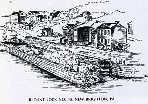
Below Clarke's Mill, down as far as Brighton, a distance of 14.44 miles, I propose to make slack water navigation; I have accordingly located a towing path on the bank of the Beaver, all the way to that place, and as many dams as I considered necessary to effect the object in the most economical manner. Dam No. 1 is located at Newcastle across the Neshannock and is made as above stated, for taking out the water of that stream for a feeder. No. 2 is located at Hardscrabble, and makes the first pool 1.92 miles long. No. 3 is located a little above the mouth of the Connoquenessing, and makes the 2d Pool 4.22 miles long. No. 4 is located at Dr. Adams, at the head of the falls of Beaver, and makes the 3d pool 7.16 miles long. No. 5 is located at Brighton at the site of Mr. Patterson's dam, and makes the 4th pool 1.10 miles long. Their dimensions are given in the estimates. At the 2d and 4th dams, I have located short pieces of Canal. That at the 2d dam is 13 chains long, and that at the 4th is 32'/2 chains long. These enable us to pass round the dams, and to obtain a convenient place to debouch into the pools below.
From Dam No. 5, I have located a canal, down as far as the 543 Station, opposite to Fallston, a distance of 1.31 miles. This location I considered necessary for 2 reasons: first, because it will not cost any more than slack water navigation, and will be safer; and second, because it will not interfere in any respect with the numerous water privileges upon this portion of the line. These are considered of great importance to this part of the country, and it has been a principal object in my location, to save them, wherever it could be done without sacrificing the interest of the state. In the present instance I am satisfied that this object has been attained.
All the locations to this point I have made upon the east side of the stream, and for this reason-I have not been able to perceive any advantage in crossing, to counterbalance the expense and inconvenience which that measure would occasion.
From the 543 Station, down to the mouth of Beaver, a distance of 2.72 miles, I have thot proper to present you with 2 plans of improvement. The first is by slackwater navigation, making a dam a little below the Bridge at Bridgewater. This would make a pool extending back to Fallston, and confer upon that place and the immediate villages, all the advantages which they could expect, without injuring any of their water power. This plan is accompanied with separate estimates for a towing path on both sides of the stream as far as the dam. Also with an estimate for an outlet canal to the River on the west side, passing down the channel, which opens into the Ohio by Col. Stone's and one for a canal on the east to connect with the River at the mouth of Beaver; and also for one terminating about 70 rods above the mouth. The 2d plan is to make a continued canal all the way to the river. I have examined both sides and made a separate estimate for both. That for the east side is annexed, and the others I will show you if you wish it.
I will now only add that I am decidedly in favor of slack water navigation. It will cost much less than a canal, as you will perceive by a comparison of the estimates; and is in my opinion much better adapted to the commerce of the country. Upon this question however, I leave you to decide, and also in case of slack water which side of the stream will be best for the towing path & where it will be best to clebouch into the river.
In regard to my estimates, I will only say that I believe they are sufficiently high to cover the cost of the work, but upon this subject I do not pretend to be entirely positive. It is true I have encleavoured to take every expense into consideration which could reasonably be anticipated, but in the progress of the work there are generally a variety of contingencies, such as hardpan, rock, quicksand, & etc, which it is impossible to foresee or form any certain estimate of; and upon streams like the Beaver and Ohio, which frequently rise from 10 to 20 feet in a single night, with a current from 5 to 10 miles an hour, bearing upon their floods large trees and ice, and sometimes the wreck of Mills, swept down by the resistless current, it is impossible to say what damage may be done to the banks or walls of the canal, and particularly to the mechanical work while in an unfinished state.
For these contingencies I have allowed on the canal, tow path locks, aqueducts, etc.., 10 per cent; and upon the dams 20 per cent-, as you will see in my summary estimate.
Respectfully your Obt. Svt.
CHARLES T. WHIPPO
Beavertown, July, 1831.