Part 1 of M. R. Stealey's Map of the canals in 1833.
Click Here to Return To Milestones Vol 6 No 2
0.0 Mouth of the Beaver River. Beaver Point on the east bank, Stone's Point on west. Joins Ohio River at Mile 25.5.
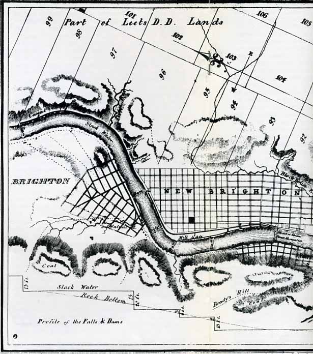
0.3 Girard Locks, No. 16 and 17 (named for Stephen Girard, Philadelphia philanthropist). Oversized locks (25' X 120) permitted passage of steamboats to pool above Dam No. 6. Bridgewater, on the west bank, was the maincanal terminus. Freight was transferred here to steamboats, or canal boats passed through locks and were towed on the Ohio River to Pittsburgh. The west abutment of the dam remains. Lock No. 17 covered by Ohio River pool raised in 1936 by Montgomery Island Dam. Lock No. 16 serves as a foundation for the Rochester sewage pumping station. The river wall is visible. Canal to slackwater pool (No. 5).
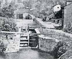
2.4 Blount Lock, No. 15. This, and all remaining locks on the
Beaver Division were 15' X 90'. This is the first of a flight
of four locks and a one mile stretch of canal. Lock No. 15 can
be seen from the Fallston Bridge. It is partly covered, but the
curved lower end of the river wall is visible.
2.5 Boyle's Lock, No. 14. Covered by the railroad embankment.
2.6 Buck Woods' or "Butt Cut," Lock No. 13. Covered by the railroad embankment.
2.7 Van Lear's Lock, No. 12. Covered by the railroad embankment. No trace of former canal bed above this point exists.
3.8 Dutchman's Lock, No. 11, and Dam No.
5. The river wall of the lock is visible. The dam was built in
1826 for water power and was incorporated into the canal system
in 1831, then rebuilt in 1869, with a 20 foot fall. Across the
river, part of the Beaver Falls water power canal remains. Some
freight was moved on this waterway by boats which crossed the
slackwater pool above the Dam (No. 5). In 1976, two local industries
(Mayer China and Republic Steel) were still using the canal for
hydroelectric power. Canal to slackwater pool (No. 4).
4.8 Canal resumed separate channel. Drill marks in native stone
on shore show location.
4.9 Bannon's Lock, No. 10. Ten foot lift. Nothing remains.
5.1 Farrow's Lock, No. 9. The west wall of this lock is tumbled
and scattered, but easily recognized. The right wall is covered
by the railroad embankment. Five foot lift.
5.3 Dam No. 4, built 1832 (The first dam on the Beaver River was
built here prior to 1800.) The slackwater pool (No.3) above the
dam was called the "Seven Mile Level".
12.3 Mouth of the Connocluenessing Creek. Canal crossed on slackwater. This is the site of the incident in which young James Garfield nearly drowned, when he was a mule driver on the canal.
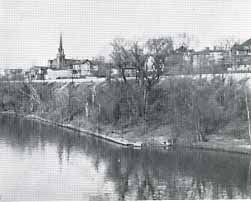
12.4 Rock Point Lock No. 8 and Dam No. 3 (8 foot lift). A short stretch of watered canal remains, but there is no trace of the lock or dam. Metheny's Tavern, built in 1836, offered shelter to travellers on the canal and later the New Brighton and New Castle Railroad. Building collapsed in 1936, the foundation remains. Canal to slackwater (No. 2).
14.0 The improved river channel in this stretch was called "Hardscrabble" because the current was swifter here than in other parts of the canal, and upstream travel was relatively more difficult.
16.6 Beaver Division Lock, No. 7 (10' lift). Locksite remains, some stone in place, but badly ravaged by flood waters over the years. Site of the former village of Staylesville, now completely gone. Short stretch of canal on either side of the lock.
16.7 Dam No. 2. No trace visible. Canal to slackwater (No. 1).
18.6 Beaver Division Lock, No. 6 (9 foot lift), and end of slackwater navigation on the Beaver River. No trace of the lock, which was located below East Moravia at the Point where the river swings to the west.
18.9 Beaver Division Lock, No. 5 (9 foot lift). Located along Canal Street in East Moravia, about 100 yards north of Penna. Route 168. Locksite discernible by topography. A dry dock was located just above this lock. A well preserved stretch of towpath extends from here to Lock No. 4.
19.2 Beaver Division Lock, No. 4 (9 foot lift). Discernible by topography. A few stones remain. Best remaining section of towpath at this point.
19.8 Northernmost visible trace of the Beaver Division Canal-the wet ditch between highway and railroad at the underpass opposite the Penn Power generating plant.
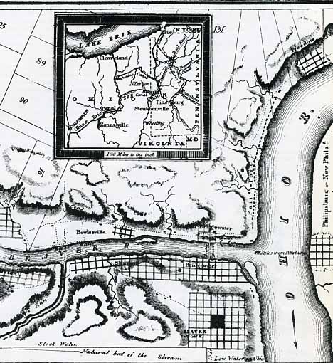
21.7 New Castle Junction. The Pennsylvania and Ohio Canal joined the Beaver Division Canal at this point. The P&O led to Youngstown, Warren, and the Ohio and Erie Canal at Akron. The canal crossed the Shenango River on an aqueduct, then followed the Mahoning River west to Ohio. There are no visible remains of the canal in Pennsylvania.
22.5 Seaman's Lock, No. 3 (9 foot lift). Covered by railroad tracks, and no trace remains. Site is 0.7 miles north of railroad crossing, near Mahoningtown bridge.
23.3 Long's Lock, No. 2 (10 foot lift). Covered by railroad tracks, and no trace remains. Site is just south of Gardner Avenue, adjacent to Big Run.
23.4 Big Run Aqueduct. Foundation of existing railroad trestle across Big Run may be part of the aqueduct base.
24.3 Beaver Division Lock, No. 1. Near former Rosena Furnace. Covered by single railroad track east of Croton Avenue.
24.4 Dam on Neshannock Creek (not numbered). No trace remains. Canal crossed on slackwater above dam, between existing Grove Street and Mill Street bridges. Spur canal extended southwest along Neshannock Creek to the iron industries below.
24.7 Beaver Division Canal crossed New Castle on route adjacent to South Street, then entered the Shenango River above Dam No. 1, of which no trace remains. Canal to slackwater pool.
29.0 Western Reserve Harbor, terminal port on the Beaver Division.
31.0 Nominal end of the Beaver Division Canal, based on mileage stated in engineering reports. The Erie Extension began here and led to Sharon, Greenville, Meadville (via the French Creek Feeder), and Erie. The Extension was completed in 1845.