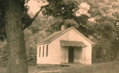
McCloy School circa 1951
Click Here to Return to South Beaver Index
Click Here to Return to Booklet Index
Much of the township where farms, roads,
and houses now stand was, about four million years ago, a part
of a mass of land known as "Appalachia". During this
early Cambrian era it was a swampy land mass that rose and sank
alternately for a few million years, It had a heavy cover of vegetation
which formed, eventually, the vast coal deposits as well as sandstone
and shale. On the Ernest Groth farm has been found many fossilized
rocks containing marine life and shells. Also, two similar rocks
were found which were at first thought bo be the hooves of an
early prehistoric animal but now they are believed to be petrifrified
stalks of plants.
During the next age, the Traisssic period, the forces of erosion
wore away thousands of feet of the old strata and the land became
closer to the level of the of the sea.
The first inhabitants were a part of the Paleo-Indian Epoch that date from 18,000 to 8,000 years ago or from 16 to 6000 B.C. They lived as stone age inhabitants, were game hunters and moved from place to place.
The next era of Indian pre-recorded history is the Archaic Epoch from 8,000 to 3,000 years ago. They are known for their graves and had the same general appearance as the Indians we know. (We do not know what the Paleo-Indian looked like.)
The Woodland Epoch stretches from 3,000 to 400 years ago and ended with the coming of the white man to this state. These inhabitants left behind many pieces of pottery, arrowheads, weapons, and other things which have been found in various parts of the township. They were much more advanced in their civilization and farmed, gathered food, fished, hunted, and cooked or boiled their food into stews and soups. They had many permanent houses and villages. However, they were small people about five feet five inches tall and weighed about 120 to 130 pounds.
Indians living in this territory were of Iroquionian extraction and were completed annihilated by the Iroquios tribe of the Five Nations about twenty years before William Penn arrived in the state. The land then became their hunting ground.
As the Indians in the eastern part of the country were forced westward by the white man, they passed across this region and some stayed for limited lengths of time. The Delawares arrived about 1760 followed by the Munsee (a Delaware tribe), then the Shawnees, the Mohicans (an Algonkian tribe), the Chippewas, the Ottawas, Mingos, Wyandots, and the Cherokees.
However, in 1780 the Federal Government allotted portions of the land to veterns of the Revolutionary War. But with the hostile Indians still present in the area, many of the new settlers were compelled to flee their homes, barely escaping with their lives. Later some returned to reclaim their acreage to find it occupied by someone else and many disputes resulted.
Further complications arose when large land companies, organized by wealthy people, endeavored to secure large tracts of this land. It was required to pay seven pounds, ten shillings per hundred acres. This township was bought almost entirely by one of these companies, the Pennsylvania Population Company. These companies in turn sold the property to the incoming settlers at a higher price. Also, some settlers ignored the boundaries and improved as much as 400 acres. Lawsuits and 1itgations resulted and it greatly hindered the settlement of the area. Large numbers moved on to Ohio and other northwest territories.
Only a few Indians remained after the Treaty was signed. Those that stayed were content, for the most part, to live peaceably. The last known Indian had his cabin on the north side of the North Fork of the Little Beaver Creek near the new Greif Brothers plant. He lived close to the first main road in the County. The road between Beaver Town and Youngstown passed aoross the east side of South Beaver Township.
A substantial Indian settlement was located at ths new Industrial Development site. It is also reported the famous Indian, Half King, a Delaware from Logstown had his hunting cabin in that region. The Watts Mill site is believed to have been a Mingo village.
The main route to the west passed through one side of the township. One resident living today, Harry Groetzinger, remembers the old Tuscarora Indian trail. It came close to the Lisbon Road and was several feet wide. The path was beaten bare of vegetation and a groove was worn several inches lower than the adjoining ground. It lead from Pittsburgh to Ohio and points west. As most Indian trails it stayed, for the most part, to the higher ground so the traveler could look down on any would be attacker .
In 1800 Beaver County was formed from Washington and Allegheny Counties. Land north of the Ohio River was considered to be "The Indian side of the river" . Only 8 few brave settlers lived here before the Treaty of Greenville, signed in 1795.
The name South Beaver is rather difficult for many to understand since it is in the northerm part of BeaverCounty but it was named this because it lies south of the North Fork of the Little Beaver Creek.
In 1800 there were 5,776 people living in the County and in 1810 1,351 lived in South Beaver Township. Then, Chippewa Township was formed cutting South Beaver almost in half. In 1820 the population was 829, with Chippewa having a population of 580. In recent years it has beganto grow at a rapid rate:
1930 1940 1950 1960
655 883 1,060 1,720.
with an area of 28.88 square miles.
One of the mysteries in the township is the "Rock". It is situated on a high hill just south of the Little Beaver Creek. It is about five feet long across the face and about three or four feet wide and no one knows how deep into the ground it goes. Some think is was an Indian Sun God, some think it was the Rain God, and some think it was made by a white man. The land was originally owned by a family named White. The Elder farm adjoined the White land. A living descendent, Chalmers Elder,states that as a small lad Mr. White told him the family had hired a slightly retarded farm hand that was also a stone mason. The man was concerned about the birds, high up on the hill. He thus made this stone into an elaborate bird feeder. The round holes were for the feed, the square hole for the water. As Mr. Elder pointed out, why would Mr. White have told him this if it were not true. But to many the question remains unanswered. Were the Indians capable of carving the hard sandstone with their crude tools? Some say yes, and some say no. There are no other stones visible on the hill. Was the stone carted or carried up there? Was it a part of the landscape? Perhaps, no one will ever find the answer. Nevertheless, it remains an interesting part of our township.
The first mill on the Little Beaver Creek was Watts Mill. There was also a saw mill at the side. Frank Steele remembers going there as a boy, and since he was a lad of curious nature,he went down below to find out how it operated. He found that the mill wheel laid on its side. Perhaps, this is a unique feature as yet I've not found any other mill that operated in this fashion. It was especially well known for its buck wheat flour. Buck wheat can only be ground in cold weather. Residents brought their bags of buck wheat during the winter and picked them up a few days later. The entire mill burned during the First World War after it was struck by lightning. It burned January 14, 1915. It became known as Watts Mill after 1840 when its original owner and builder died.
George Foulkes built Watts Mill. George had a rather unusual background. In 1780 when George was eleven years old he was captured and carried off by the Indians. A brother, age18, was killed and scalped during the incident. His sister, age 9, Elizabeth along with two other boys and two other girls were also kidnapped. Elizabeth married eventually Samuel Whitaker, one of the other captives. George lived with the Indians for 18 years and was able to learn a great deal about the ways and habits of Indian living. After his release he became a close friend and scout of Captain Samuel Brady.
Upon his return from captivity he married Catherine Ulley and when peace was restored, he built his mill. George died in South Beaver Township in 1840.
It is interesting to note that the first white settler north of the Ohio River was William Foulkes. Perhaps, he was directly related to George. He lived between Salem and the Little Beaver Creek, which would be in South Beaver Township. He is reported to have settled here in 1791, prior to the setting up of the land to the Revolutionary Veterans. When the land was purchased by the Pennsylvania Population Company a dispute and lawsuit followed. There were several other settlers living near William by this time but the first lawsuit was against only the Foulkes [family. He had by that time 80 acres under cultivation, a two story house and a double barn. The court verdict was in favor of the land company and an eviction notice was dispatched! When the sheriff and party reached the beginning of the Foulkes' lane they were fired upon by persons concealed in a thicket. James Hamilton, a zealous partisan of the land company and a settler under them was heard to say, "Sheriff, I am gone". Whereupon he died of a mortal gun shot wound. Nathanial Eakin, a neighbor of William's, was charged with the murder. This was the first murder trial in the County. The Jury, howover, returned the verdict of not guilty.
The first murderer to be executed in Beaver County was also a South Beaver resident and the victim was too. John Ansley, who lived near Black Hawk, lost a large bay horse. Soon after its disappearance he thought he saw it being ridden by a twenty year old young man named Eli Sheets. Eli lived near what is now Brownie's Inn on Old Darlington Road. John went there to face Eli with the accusation. Word spread that John was on his way. Some time later John was found dead in the vicinity of Brownie 's Inn. He had been shot twice through the head, three times through the back and once through the arm, resulting in instant death. Eli was arrested and convicted and condemned to die by hanging. He escaped, however, from jail. He was free several days before the sheriff received a tip as to where he was hiding. He was. recapturedby a sheriff's party when found hiding under a bed in the home of Mrs. Dr. R. B. Barker, whose home was situated on the river's bank. He was finally executed on April 10, 1863
Aside from the Foulkes family, almost all the residents and land owners were of Scot, Irish, or English origin. They were likewise mostly of the Protestant faith, pricnipally Presbyterian. In the 1876 Beaver County Atlas are pictures of ten of the township's homesteads.
The earliest church within the boundaries of the present lines of the township was a Methodist Church. Only the foundation stones remain at the fork of Moore Road and OhioviIle Road (Route 168). There was no graveyard. We do not know when it was organized or when it passed from existence. The present Brush Run Methodist Church was started at the turn of this century.
There are two private family cemetaries. Both are less than a mile off of main roads in woodsy settings. The Johnston family plot is on the present Swartz farm on Sterling Road. An iron fence had been erected around the plot about 1920 which lasted about 25 years.
The Conkle Court Cemetary is located about a half mile west of the Ohioville Road on Lawrence McMillan's property. In the spring it is quite beautiful with daffodills and mountain laurel in bloom over the graves.
This house is believed to be the oldest house in the township. It was built by the Wilson family just south of the banks of the Little Beaver Creek near the junction of Ohioville Road (Route 168) and State Route 51. It was abandoned fully furnished, piano and all, about 1955. A good slate roof has protected it somewhat from weathering. It sits now in the center of a mining operation. It was built in the early tradition of a kitchen with a huge fireplace and loft above. Perhaps, this was constructed first with the main house added later. The stone walls are three feet thick. The hand hewn beams show many axe marks in the attic. There is a fireplace in the main house and one in the upstairs bedroom. The shutters now swing squeekily in the wind.
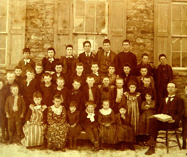
There were 8 one-room schools operating in the township. No. 1, McElheny; No. 2, St. Rest ; No. 3, Grosscost; No. 4, Court; No. 5, Johnson; No. 6, Blueridge; No. 7, McCloy; and No. 8, Limelkilm. Some of the structures are still standing. The Blueridge school was picked up and moved several miles and is now a summer home. One of the Johnston men was killed by a runaway horse while it was being moved.
The principle settlements that served the people were Darlington, Black Hawk, and Rowetown. Black Hawk is on the Old Tuscarora Indian Trail and was a stage coach stop with an Inn. Rowetown has almost from existence. There is now a market located there. It was at the crossroads of Ohioville Road (Route 168) and Blackhawk Road Route 251). It had a post office for a number of years, a black smith's shop and a saw mill. There were several homes and the Garvin homestead was torn down a few years ago. The house that served as a postoffice is now occupied by a Smith.
The township is filled with many fine and wonderful people. Two fascinating people are Clyde Howard Lightfoot and Lewis Carlisle.
Howard Lightfoot has as one of his hobbies steam engines. He has several large pieces but the most interesting i8 his small gauge steam railroad. lt runs on a small track and many Sunday afternoon he steams it up and takes friends addneighbor children for rides. His other unusual hobby is his large theater pipe organ. He purchased it from a churchin Pittsburgh and reassembled (and in many instances improved) the 676 pipes, 49 note carillon harp and 20 note chimes, in his machine and tool shop. Mr. Lightfoot found the roof was too low to accom.modate the bass pipes and it was necessary to raise the roof in that spot. He cannot play the instrument himself but his mother has been getting more proficient every year. 'The family lives on Elmbrook Road, Just north of Blackhawk Road.
Lewis Carlisle has been totally blind, as are several other members of his family, since his late teens. He managed however, to build a lovely brick home on Ohioville Road. His wife assisted him where she could, but Mr. Carlisle claims the Almighty helped too, or else he never could have completed the project.
There are, many other facts and stories connected with the beginnings of South Beaver Township. I have included all that I could find out about.
The township has grown from a wilderness to a thriving area populated by fine, hard working Americans. Those who came earliest, came not to a ready made civilization but with great determination and their strong hands cleared the land and made it productive for those who followed after. It has a rolling landscape but still its native beauty remains undisturbed. There are peaceful, wooded, gravel roads as well as busy highways, Many mail boxes still carry the names of those who first homesteaded this region.